Jakarta's Vulnerability to Global Warming
Floods in Jakarta, originally uploaded by cintafoto.
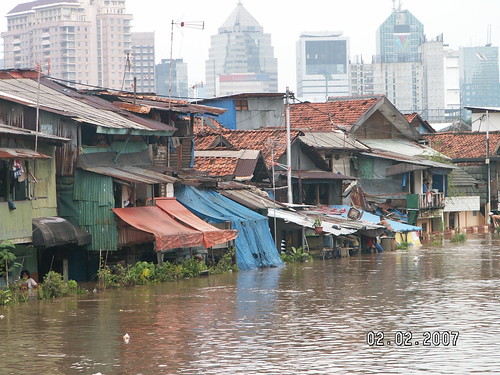
Sea-level rise is not the only threat to the vulnerability of Jakarta due to the climate change. February's floods in Jakarta which inundated more than 70 percent of Jakarta and sent about 450,000 fleeing their homes is strong evidence that torrential rain could be a serious threat for Jakarta. Bigger storms make Jakarta which lies in the lowlands, near the sea, and is crossed by 13 rivers flowing down from the south even more vulnerable.
The vulnerability of Jakarta would be even worse if the exploitation of groundwater in Jakarta and the conversion of water catchment areas into urban ones in Jakarta's peripheral areas could not be reduced. Both factors contribute to the land subsidence in Jakarta that has happened in many years. The land subsidence in Jakarta was first identified by researchers when the Sarinah bridge at Jalan M.H. Thamrin was found cracked in 1978 (Djaja, et. al., 2004). Since then, the measurement of land subsidence in Jakarta has been conducted and the rate of land subsidence in Jakarta has been increasing over years particularly in the northern part of the city.
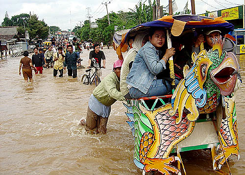
Floods in Ciledug, Jakarta, originally uploaded by sri nanang setiyono.
According to the Jakarta Mining Agency, the main causes of the land subsidence in Jakarta include the construction of new building particularly high-rise building and water usage. Due to limited piped water supply, the majority of Jakarta population rely on groundwater for their water needs. The Jakarta Mining Agency estimated that about 66,000 gallons of water were extracted from the Jakarta's aquifer every year. Such intensive groundwater withdrawal accelerates the land subsidence in Jakarta.
The land subsidence in Jakarta was exacerbated by the decreasing water catchment areas both in Jakarta and the outskirts of Jakarta. The decreasing water catchment areas will reduce the volume of water that sink into the ground for recharging the groundwater. The mismatch between the intensive groundwater withdrawal and recharge of groundwater is the major cause of land subsidence.
Jakarta is one of many other coastal cities in the world that needs to adapt to survive from the global warming. Some major coastal cities have taken action to mitigate the impact of sea-level rise. Most commonly used action is building hard structure such as dikes and sea walls such as in the Netherland, London and Beijing. The Netherlands is preparing to raise the North Sea defenses from 1-in-10,000 to 1-in-100,000 years level of protection. London has also preparing to add 12 inches of protection on top of the existing floodgates to keep ocean-storm surges from flooding the city.
Jakarta needs not only to protect the city from sea-level rise but also from the land subsidence. In addition to building dikes and sea walls, Jakarta needs to reduce significantly the use of groundwater as water main source for the residents. As many water reservoirs as possible need to be built to conserve the groundwater. The conversion of land use in water catchment areas also need to be prevented. The water catchment areas should be protected. Such protection will allow more water to sink into the ground and recharge the groundwater. Reducing the use of groundwater and protecting water catchment areas will decelerate the land subsidence and decrease the vulnerability of Jakarta.
Reference:
Djaja, R., Rais, J., Abidin, H.Z., and Wedyanto, K. (2004). Land Subsidence of Jakarta Metropolitan Area. A paper presented at the Third FIG Regional Conference in Jakarta, October 3-7, 2004
(This article also appeared at The Jakarta Post on April 28, 2007 and then was linked at Planetmole and Environment-Indonesia)


3 comments:
Pak Deden, salam kenal. Great article. Just a minor typo perhaps: "The Jakarta Mining Agency estimated that about 66,000 gallons of water were extracted from the Jakarta's aquifer every year". I think perhaps 66,000 gallons/year is too small. Perhaps it is 66 million gallons. The typical truck/tank is 3000 to 6000 gallons per truck. [TH]
Just another thought for this global warming, increasing or maintaining urban biodiversity... How about that? I think it should also combined with the concept of urban landscape
Dear Pak Deden,
I would like to ask you whether the current development in northern coast of Jakarta, such as luxurious apartments and malls in Pluit area, and other apartment complex in Ancol Dreamland has anticipated the impact of the predicted rising sea level by 2025 as the consequence of global warming? How about the plan, if any, from Jakarta administration to tackle the threat of rising sea level in Jakarta in the future? And how low is Jakarta now compared to sea level, Does this city lie 1 or 2 meter below sea level? Thank you. Rud
Post a Comment