Rapid Urbanization and the Need for Sustainable Transportation Policies in Jakarta
I was one of the keynote speakers of the 2016 International Conference on Science, Infrastructure Technology and Regional Development (ICoSITeR) hosted by the Sumatera Institute of Technology on September 28-29, 2016 in Bandar Lampung, Indonesia. The conference organizer asked me to submit my paper for the inclusion in the conference proceeding.
Below is my paper submitted to the conference organizer for the inclusion in the 2016 ICoSITeR proceeding. The paper was submitted on May 9, 2017.Introduction
Jakarta is the capital of
Indonesia and the largest metropolitan area in Southeast Asia with tremendous
population growth, land use change and new town and industrial estate
development. The overall population of the Jakarta region grew in the 20th
Century, from about 150,000 in 1900 to about 30 million in 2014. This paper
discusses urbanization and suburbanization in the megacity of Jakarta and
analyzes the extent to which rapid urbanization in Jakarta has contributed to
the need for sustainable transportation policies in Jakarta. The development
and expansion of Mass Rapid Transit are documented and the use of private
vehicles and the development of elevated toll roads and bike lanes also
critically analyzed.
Population Growth of the Metropolitan Region of Jakarta
Jakarta has been the capital of Indonesia since the
Dutch colonial era. The population of Jakarta in 1900 was about 115,000. In the
first nationwide census of the Dutch colonial administration (1930), Jakarta’s
population increased to 409,475. In the next ten years, the population
increased to 544,823 with an annual growth rate of 3.30%. After Independence,
Jakarta increased by nearly three times to 1.43 million by 1950. It increased
to 2.91 million in 1960 and 4.47 million in 1970. The annual growth rates of
Jakarta’s population are 10.35% and 5.36% (1950-1960 and 1960-1970 respectively).
Table 1 shows the population of the metropolitan region of Jakarta including Jakarta, the inner and outer peripheries of Jakarta, from 1980 to 2010. The Megacity of Jakarta increased from 11.91 million in 1980, 17.14 million in 1990, and 20.63 million in 2000 to 28.01 million in 2010. The megacity in 2010 was 11.79 percent of Indonesia’s total population but this population resides in less than 0.3 percent of Indonesia’s total area. The proportions of Jabodetabek’s population to the total population of Indonesia have steadily increased from 8.07%, 9.56%, to 10.0% (in 1980, 1990, and 2000 respectively).
Table 1 shows the population of the metropolitan region of Jakarta including Jakarta, the inner and outer peripheries of Jakarta, from 1980 to 2010. The Megacity of Jakarta increased from 11.91 million in 1980, 17.14 million in 1990, and 20.63 million in 2000 to 28.01 million in 2010. The megacity in 2010 was 11.79 percent of Indonesia’s total population but this population resides in less than 0.3 percent of Indonesia’s total area. The proportions of Jabodetabek’s population to the total population of Indonesia have steadily increased from 8.07%, 9.56%, to 10.0% (in 1980, 1990, and 2000 respectively).
Table 1. Population of the Metropolitan
Region of Jakarta in 1980-2010 (in millions)
Area
|
1980
|
1990
|
2000
|
2010
|
Core
|
6.50
|
8.26
|
8.39
|
9.60
|
Jakarta
|
6.50
|
8.26
|
8.39
|
9.60
|
Inner
peripheries
|
n.a
|
n.a
|
4.93
|
7.22
|
City of Tangerang
|
n.a
|
n.a
|
1.33
|
1.80
|
City of South Tangerang
|
n.a
|
n.a
|
0.80
|
1.29
|
City of Depok
|
n.a
|
n.a
|
1.14
|
1.75
|
City of Bekasi
|
n.a
|
n.a
|
1.66
|
2.38
|
Outer
peripheries
|
5.41
|
8.88
|
7.31
|
11.20
|
City of Bogor
|
0.25
|
0.27
|
0.75
|
0.95
|
Tangerang Regency
|
1.53
|
2.77
|
2.02
|
2.84
|
Bekasi Regency
|
1.14
|
2.10
|
1.62
|
2.63
|
Bogor Regency
|
2.49
|
3.74
|
2.92
|
4.78
|
Megacity of
Jakarta
|
11.91
|
17.14
|
20.63
|
28.02
|
Sources: Rukmana
(2014)
Transformation of Jakarta
The modern city of Jakarta was initiated by
President Soekarno’s strong vision to build Jakarta into the greatest city
possible (Cybriwsky and Ford, 2001). He gave Jakarta, Monas – his most symbolic
new structure the 132 m high national monument, spacious new government
buildings, department stores, shopping plazas, hotels, the sport facilities of
Senayan that were used for the 1962 Asian Games, the biggest and most glorious
mosque of Istiqlal, new parliament buildings and the waterfront recreation area
at Ancol.
Such constructions continued under the New Order
regime that began in 1967. Under this regime, Indonesia enjoyed steady economic
growth, along with a reduction in the percentage of the population living under
the poverty line. Jakarta grew rapidly during this period of the New Order
regime. During the thirty-two years of the New Order regime, Jakarta changed
considerably. A generally rapid economic growth during this period allowed
Jakarta to expand its modern constructions and develop into a modern city.
Hundreds of new office towers, hotels and high-rise condominiums were built in
many parts of the city.
The massive development on the outskirts of the
megacity of Jakarta resulted from a series of deregulation and
de-bureaucratization measures enacted by the Suharto government in the 1980s
(Winarso and Firman 2002, p. 488). The subsidized housing finance program and
municipal permit system for land development also contributed to policies that
have most benefited some developers strongly linked to the New Order regime
(Leaf, 1994). Winarso and Firman (2002) revealed almost all large developers
were well connected to the President Suharto’s family and inner circle
including his daughters, sons, brother, in-laws and close friends. The
connection to the Suharto family and inner circle became significant; closeness
to the first family helped the large developers expand their business.
Interlinking also occurred among the large developers through
cross-shareholding, shared directorships and joint ventures; procees which
turned potential competitors into collaborators and created oligopolistic types
of land and housing markets.
Continuing with the suburbanization; this was also
caused by the development of three highways stretching from Jakarta to the
peripheries - the Jagorawi toll road, the Jakarta-Cikampek toll road, and the
Jakarta-Merak toll road (Henderson and Kuncoro 1996). The development of
private industrial parks in the peripheries naturally followed the development
of these highways (Hudalah et al 2013).
Private industrial parks in the peripheries range from 50 to 1,800
hectares and on average the size is about 500 hectares (Hudalah et al 2013);
major industrial centers are located in Cikupa-Balaraja of Tangerang Regency
and Cikarang of Bekasi Regency. The industrial center of Cikarang with a total
industrial land area of nearly 6,000 hectares is the largest planned industrial
center in Southeast Asia (Hudalah and Firman 2012).
Jakarta’s
Transportation Problems
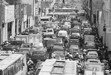
The urbanization and
suburbanization in Jakarta are strongly associated with the traffic congestion
in Jakarta. Jakarta is estimated to lose US$3 billion a year because of traffic
congestion which can’t be separated from the high growth rate of vehicle
ownership (9 to 11 percent per year), unsupported by road development (less
than 1 percent a year).
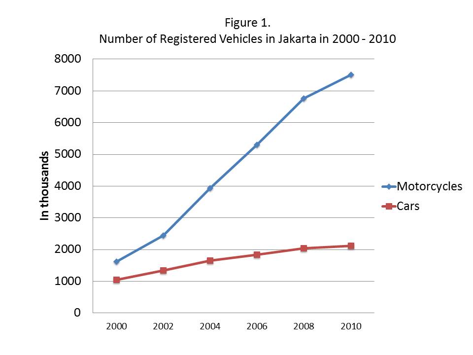
Motorcycles are ubiquitous and
can be acquired with a down payment of as little as $30. The number of
registered motorcycles in Jakarta grew exponentially from 2000 to 2010 as seen
in Figure 1. The trend of the motorcycles growth will continue until a more
sustainable transportation policy is implemented.
People who live in the outskirts
of Jakarta can save as much as 30% of their transportation costs using
motorcycles to work rather than public transport. The daily jams in Jakarta are
getting worse; the peripheries are a “bedroom suburb” for the daily commuters
of Jakarta, the center of government and corporate offices, commercial and
entertainment enterprises. The economy of Jakarta dominates its peripheral
areas. In the daytime, the total population in Jakarta is much more than its
population in the nighttime; the number of daily commuters in Jakarta is
estimated 5.4 million.
The economy of Jakarta dominates
its peripheral areas. In the daytime, the total population in Jakarta is much
more than its population in the nighttime; the number of daily commuters in
Jakarta is estimated 5.4 million. The level of services of public
transportation in Jakarta is not reliable and accessible. People who live in
the outskirts of Jakarta can save as much as 30% of their transportation costs
using motorcycles to work rather than public transport.
Commuters from the peripheries
primarily used three highways including the Jagorawi toll road connecting
Jakarta and the southern peripheries, the Jakarta-Cikampek toll road connecting
Jakarta and the eastern peripheries and the Jakarta-Merak toll road connecting
Jakarta and the western peripheries. Most commuters go to Jakarta to work in
government and corporate offices, study in universities, receive high quality
medical attention in the hospitals, and/or go for entertainment and cultural
activities. The current public
transportation systems have not been able to alleviate the acute traffic
congestion; it is likely that Jakarta needs a Mass Rapid Transit (MRT) or also
popularly known as Metro, in order to address this problem. Jakarta is the
largest city in the world without a ‘metro’.
Most metropolitan areas in the
world with the population of over 10 million have operated metros for years.
New York City opened the first underground line of its subway in 1904 and since
then the subway has been the backbone of New York City transportation system.
Two major cities in Japan, Tokyo and Osaka built their metros in 1927 and 1933
respectively. The Tokyo Metro is the world’s most extensive rapid transit
system with more than eight million passengers daily. The second largest city
in the world, Mexico City, has had a metro since 1969 and now the Mexico City
Metro is the second largest metro system in North America after the New York
City subway. Two major cities in China, Beijing and Shanghai opened their metro
systems in 1971 and 1995 respectively. Major cities in Southeast Asia with
smaller populations than Jakarta have also had their metro systems for years,
including Manila (1984), Singapore (1987), Kuala Lumpur (1995) and Bangkok
(2004).
The Need for
Sustainable Transportation Policies in Jakarta
Rapid urbanization in Jakarta has
contributed to the need for sustainable transportation policies in Jakarta. The
growth of registered vehicles in response to the growth of population in
Jakarta and its peripheral areas has caused acute traffic congestions in
Jakarta. This section will offer several ideas of sustainable transportation
policy including reducing private vehicle uses, promoting bike lanes, and the
development of MRT.

Reducing private
vehicle uses
There are several possible
solutions to eradicate traffic congestion problems and one of them is the
reduction of private vehicle uses. The New York Times reported a suburb town
without cars in Germany. Streets in this upscale town are completely car-free except
the main thoroughfare and a few streets on edge of the town. The residents of
this town are still allowed to own cars, but parking is relegated to two large
garages at the edge of the development.
The Vauban town, is located on
the outskirt of Freiburg, near the French and Swiss borders and home to 5,500
residents. The residents are heavily dependent on the tram to downtown Freiburg
and many of them take to car-sharing when longer excursions are needed. Seventy
percent of Vauban's families have no cars. They do a lot of walking and biking
to shops, banks, restaurants, schools and other destinations that are
interspersed among homes. The town is long and relatively narrow and provides
an easy walking access to the tram for every home.
Creating places with more compact
design, more accessible to public transportation and less driving is the
envision of urban planners in the 21st century. The Vauban town is an exemplar
of the 21st century urban design in response to the threats of greenhouse gas
emission and global warming and the dwindling oil supply. The Vauban's urban
design is the extension of the New Urbanism. The New Urbanism is a school of
urban design arose in the U.S. in the early 1980s. This school of urban design
promotes several key principles including walkability and connectivity, mixed
land uses, and high density. There have been many the New Urbanist towns in
several countries, but cars still fill the streets of these towns.
The Vauban town provides an
example of the possibility of creating city without cars. The walkable and
mixed-land-uses urban design, easy access to public transportation and
excellent public transportation system as demonstrated in the Vauban town are
the components for creating city without cars.
Cars are still a luxury item for
many Indonesian families. Many urban residents, particularly those live in
kampung kota, do not own cars and are used to living without cars. Streets
(gang) in Indonesia's kampung kota are too narrow for cars and the residents
are used to walking and biking to their destinations. Kampung kotas are located
in the center of urban areas and relatively accessible to public
transportations. In reference to the New Urbanism concept, the Indonesia's
kampung kota has implemented the principles of walkability and high density.
Indonesian planners need to
appreciate the existence of kampung kota in terms of lacking driving needs.
Kampung kota residents will be less likely to have a demand for cars when their
neighborhoods are accessible to public transportations and the streets in their
neighborhoods remain narrow. Kampung kota residents need to remain lack of
driving needs for reducing the car ownership rate in urban areas including
Jakarta. For new developments in suburb areas, Indonesian planners can emulate
the success of the Vauban town. Driving needs are profoundly affected by the
urban design and the high access to public transportation. It makes sense to
envision and is not all impossible to create a city without cars.
Promoting Bike
Lanes
Many metropolitans in the world
have developed dedicated bicycles lanes for years. Cities in developed
countries, particularly in Europe, have integrated bicycle lanes into their
transportation network systems. Those cities such as Amsterdam, Paris, Berlin,
Copenhagen and Barcelona have been developed as bike-friendly cities. Safe and
extensive bike route networks, promotion of pro-cyclist policies, and a bike
culture have taken places in those cities. Cyclists in those cities are not
second class residents and can safely ride their bicycles as the main mode for
their daily commute to their workplaces. Copenhagen is an example of European
bike-friendly city where about a third of workforce in this city commute to the
office by bike.
The first Jakarta’s dedicated bike lane stretching from Ayodia Park to Blok M was inaugurated in May 2011. It should be considered as a breakthrough in solutions for acute traffic congestion in Jakarta. The development of dedicated bicycle lanes is a good move from the Jakarta administration for promoting the use of bicycle as an alternative transportation mode. If the Jakarta city administration could encourage more motorists to shift to using bicycle to work, the city’s chronic traffic woes could be eventually reduced.
The first Jakarta’s dedicated bike lane stretching from Ayodia Park to Blok M was inaugurated in May 2011. It should be considered as a breakthrough in solutions for acute traffic congestion in Jakarta. The development of dedicated bicycle lanes is a good move from the Jakarta administration for promoting the use of bicycle as an alternative transportation mode. If the Jakarta city administration could encourage more motorists to shift to using bicycle to work, the city’s chronic traffic woes could be eventually reduced.
The first dedicated bike lane in
Jakarta is only a small step in developing Jakarta as a bike-friendly city.
There are many challenges for Jakarta to be a bike-friendly city. The Jakarta
city administration needs to have a strong commitment to build more dedicated
bike lanes and integrate them with the city transportation network system.
Dedicated bike lanes should be part of the city transportation network system
and designed to accommodate the need of residents’ mobility in the city. It is very
essential to connect dedicated bike lanes with mass transportations including
the Mass Rapid Transit (MRT).
It’s not easy to build more
dedicated bike lanes if the Jakarta city administration still focuses on
building more elevated inner-city toll roads as the solution of addressing the
chronic traffic woes in Jakarta. It is also important to note that the first
dedicated bike lane was not initiated by the Jakarta city administration but
the Indonesian Bicycle Community (Komite Sepeda Indonesia) that donated as much
as 500 million rupiahs to build the bike lane. The Jakarta city administration
needs to change the mindset of the possible solution for the chronic traffic
congestion in the city. The solution is not building more roads, but reducing
the use of cars through improving and expanding the use of mass transportations
and bicycles.
Another big challenge for bike
lanes in Jakarta is the lack of law enforcement. The Jakarta city
administration should strictly enforce the dedicated bike lanes for cyclists.
The dedicated bike lane cannot be used as parking spots and a lane for
motorcyclists. A few days after the inauguration of the bike lane stretching
from Ayodia Park to Blok M, the lane was overwhelmed by private cars, pubic
minivans and three-wheeled vehicles bajaj. A number of private cars were also
parking in the lane (The Jakarta Post, 27 May 2011). Without strict law
enforcement, the dedicated bike lane will not be an effective way to reduce the
Jakarta’s traffic woes and will only be a failed initiative.
Despite the challenges for bike
lanes in Jakarta, the inauguration of the Jakarta’s first bike lane should be
seen as a promising way of alleviating the acute traffic problems in Jakarta. I
hope that the inauguration of the Jakarta’s first bike lane could be the
milestone for the Jakarta city administration in changing the mindset of how to
address the chronic traffic problems in Jakarta. It is not building more toll
roads but reducing the use of cars through encouraging more motorists to shift
to cyclists or mass transportation riders.
Discouraging
Elevated Roads
The development of new roads will
never catch up to the growth rate of vehicle ownership. A new highway or a
widened road only alleviates traffic congestion for a short period of time. After
a few years, any new or widened highway fills with traffic that would not have
existed if the highway had not been built, a phenomenon called induced demand.
Because of induced demand, neither building new roads nor widening existing
roads are viable long-term solutions to traffic congestion.

The new roads will also undermine
the efforts to develop a mass transportation system in Jakarta. The main idea
of developing a mass transportation system, including the TransJakarta busway
and the monorail and Mass Rapid Transit projects, is to reduce the number of
motorists and motorcyclists on Jakarta’s streets. Drivers would be expected to
use the mass transportation and reduce traffic, but new roads would only
attract more motorists.
Not only would elevated roads
stimulate induced demand and thus worsen traffic congestion, they could also
jeopardize the livability of neighborhoods along them. In many cities in other
countries, such as Seoul, New Orleans, San Francisco and New York City,
elevated freeways have negatively affected livability. At the same time, in
many developed countries, we have seen a shift in urban planning from enhancing
mobility toward promoting livability.
The Cheonggyecheon freeway was
completed in 1977 and was seen a as a symbol of modernization and
industrialization in South Korea after the war with the North. This elevated
freeway was built above a 5.8-kilometer stream flowing through downtown Seoul.
By 2000, the area was considered the most crowded and noisy part of the city
and became an eyesore for residents.
In July 2003, the then-mayor of
Seoul and the current president of South Korea, Lee Myung-bak, launched a
project to tear down the Cheonggyecheon freeway and revitalize the surrounding
area. During the demolition process, the city administration developed public
transportation systems, including Bus Rapid Transit lines. Today, the
Cheonggyecheon area has been revitalized and is one of Seoul’s main tourist
areas.
In 1973, New York City’s West
Side elevated highway collapsed and was never repaired but replaced by a
surface boulevard of West Avenue. Similarly, two elevated freeways in San
Francisco, Embarcadero and Central Freeways, were badly damaged by the Loma
Prieta earthquake of 1989. The San Francisco city administration decided not to
rebuild the elevated freeways, but replaced them with surface boulevards. The
conversion of elevated freeways in both New York City and San Francisco did not
cause traffic havocs. The traffic switched to the boulevards, nearby street or
mass transit (James and Norquist 2010). Furthermore, a team of researchers from
the UC Berkeley (Cervero, Kang, and Shively 2009) found that the conversion of
elevated Embarcadero and Central Freeways with boulevard has stimulated
reinvestment in the neighborhoods along the freeways without seriously
sacrificing transportation performance. More recently, the residents of New
Orleans have decided not to rebuild the damaged elevated expressway caused by
the Hurricane Katrina, but replace it with an oak-lined boulevard (James and
Norquist 2010).
The conversion of elevated
freeways to surface boulevards in Seoul, New York City, San Francisco or New
Orleans is evidence of a paradigm shift from a focus on expediting the movement
of automobile to a focus on increasing the livability of neighborhoods. The
livability of neighborhoods should be prioritized over the increase of
mobility. Jakarta needs to learn from what has happened in Seoul, New Orleans,
San Francisco or New York City regarding the elevated freeways. Not only is the
proposed six elevated toll road projects the solution for the traffic
congestion in Jakarta, but also they could cause the decline of livability of
neighborhoods along the elevated toll roads. The Jakarta city administration
should revisit their decision to build the new elevated toll roads and instead
they should focus their efforts on building mass transportation systems in
alleviating transportation problems in Jakarta.
The Development
of Mass Rapid Transit
In order to address traffic
congestion, two flagship projects are underway including the development of
Cilamaya Seaport and the Mass Rapid Transit (MRT) project. The Cilamaya Seaport
is located outside of the Jabodetabek, but is connected with the
Jakarta-Cikampek toll road. This planned seaport is located in Karawang
Regency. All shipping activities of
industrial parks in the megacity are currently using the Tanjung Priok port in
Jakarta. The Cilamaya Seaport is designed to mitigate further traffic congestion
caused by heavy traffic flowing from the eastern parts of the megacity to the
Tanjung Priok port. This will be a new transportation hub for the megacity’s
industrial parks. The MRT project would become the most expensive public
projects in Jakarta’s history, but it is the answer to address acute traffic
congestions in Jakarta.

For at least 20 years, the
proposed MRT has been under discussion by the Jakarta administration and the
government of Indonesia. Activists and non-governmental watchdogs have seen the
MRT proposal as a possible bonanza for corrupt politicians and contractors
(Economist, 4 February 2010). Eventually, the government secured a $1.6 billion
loan agreement with the Japanese International Cooperation Agency (JICA) in
2009 for funding. Vice President Boediono also asked the JICA to expedite the
design and construction of MRT project; the first tract of the MRT project was
to be completed in 2016 (The Jakarta Post, 20 October 2010). The construction
of the MRT project began on October 10, 2013. Governor Joko Widodo launched the
flagship project in a groundbreaking ceremony at Dukuh Atas, Central Jakarta
(The Jakarta Globe, October 11, 2013).
One MRT train will consist of six
cars and be able to transport a maximum of 1,200 passengers per trip. The MRT
Jakarta will operate 16 trains and transport 1.5 million passengers a day. The
first MRT tract will connect Lebak Bulus, South Jakarta and the Hotel Indonesia
traffic circle with six underground stations, seven elevated stations and a
capacity of 173,000 passengers per day.
Conclusion
The growth of registered vehicles
in response to the rapid urbanization has caused acute traffic congestions in
Jakarta. The Jakarta administration needs to find sustainable transportation
policies to address the transportation problems in Jakarta. The development of
MRT could be viable solutions to alleviate the acute traffic jams in Jakarta. The
main idea behind developing a mass transportation system, including the
TransJakarta busway and the monorail and Mass Rapid Transit projects, is to reduce
the number of motorists and motorcyclists on Jakarta’s streets. Drivers would
be expected to use the mass transportation and reduce traffic, whereas new
roads only attract more motorists. Jakarta needs to discourage the development
of elevated roads that will stimulate induced demand and thus worsen traffic
congestion. Elevated roads will jeopardize the livability of neighborhoods
along them.
In addition, Jakarta will need to
promote bike lanes and reduce the use of private vehicle. Jakarta needs to encourage
the development and usage of the smartphone apps on its two-way ability to
locate, coordinate and orchestrate both passengers and vehicles and encourage
more biking and walking for its residents. Jakarta will also need to implement
other innovative sustainable transportation policies including carpool matching
services, shuttle services, telecommuting and downzoning and better parking
management in downtown areas.
References:
Cervero,
R., Kang, J., and Shively, K. (2009). From elevated freeways to surface
boulevards: neighborhood and housing price impacts in San Francisco. Journal of
Urbanism 2(1): 31-50
Cowherd,
Robert. (2005). Does planning culture matter? Dutch and American models in
Indonesian urban transformations. In Comparative Planning Culture. Bishwapriya
Sanyal (Ed.). New York and London: Routledge
Cybriwsky,
Roman and Ford, Larry R. (2001). City profile: Jakarta. Cities 18(3): 199-210.
Economist,
4 February 2010
Ernst,
J. (2005). Initiating bus rapid transit in Jakarta, Indonesia. Transportation
Research Record: Journal of the Transportation Research Board, (1903), 20-26.
Firman,
Tommy and Ida Ayu Indira Dharmapatni. (1994). The challenges to sustainable
development in Jakarta Metropolitan Region. Habitat International 18(3): 79-94
Firman,
Tommy. (1997). Land conversion and urban development in the Northern Region of
West Java, Indonesia. Urban Studies 34(7): 1027-1046
Firman,
Tommy. (1998). The restructuring of Jakarta Metropolitan Area: A “global city”
in Asia. Cities 15(4): 229-243.
Firman,
Tommy. (1999). From “global city” to “city of crisis”: Jakarta Metropolitan
Region under economic turmoil. Habitat International 23(4): 447-466.
Firman,
Tommy. (2002). Urban development in Indonesia, 1990-2001: from the boom to the
early reform era through the crisis. Habitat International 26: 229-249
Firman,
Tommy. (2003). Potential impacts of Indonesia’s fiscal decentralization reform
on urban and regional development: towards a pattern of spatial disparity.
Space and Polity 7(3): 247-271
Firman,
Tommy. (2004). New town development in Jakarta Metropolitan Region: A
perspective of spatial segregation. Habitat International 28(3): 349-368.
Firman,
Tommy. (2008). In search of a governance institution model for Jakarta
Metropolitan Area (JMA) under Indonesia’s new decentralization policy: Old
problem, new challenges. Public Administration and Development 28: 1-11
Hadiz,
V.R. (2004). Decentralization and Democracy in Indonesia: A Critique of
Neo-Institutionalist Perspective. Development and Change 35(4): 697-718.
Henderson,
Vernon. (2003). The urbanization process and economic growth: The so-what
question. Journal of Economic Growth 8:47-71
Hudalah,
Delik and Johan Woltjer. (2007). Spatial planning system in transitional
Indonesia. International Planning Studies 12(3): 291-303
Hudalah,
Delik and Tommy Firman. (2011). Beyond property: Industrial estates and
post-suburban transformation in Jakarta Metropolitan Region. Cities 29: 40-48
Hudalah,
Delik, Dimitra Viantari, Tommy Firman, and Johan Woltjer. (2013). Industrial
land development and manufacturing deconcentration in Greater Jakarta. Urban
Geography 1-22.
James,
C. and Norquist, J. (2010). Tearing down an expressway to restore a community. http://www.nola.com/opinions/index.ssf/2010/08/tearing_down_an_expressway_to.html
Kawaguchi,
H., Wachi, T., Alvinsyah, K. H., & Yagi, S. (2010). Transition in mode
choice due to motorization and improvement of public transportation system in
Jakarta. In Proceedings of the 12th World Conference on Transportation
Research. Lisbon.
Leaf,
Michael. (1994). The suburbanization of Jakarta: A concurrence of economics and
ideology. Third World Planning Review 16(4): 341-356.
Rukmana,
Deden. (2014). Peripheral Pressures: Jakarta. Archeology of the Periphery of
Megacities. Roger Connah (Ed.). Moscow: Strelka Press. Pp. 158-167
Silver,
Christopher. (2007). Planning the megacity: Jakarta in the twentieth century.
London and New York: Routledge.
Steinberg,
Florian. (2007). Jakarta: Environmental problem and sustainability. Habitat
International 31(3-4): 354-365
The
Jakarta Globe, October 11, 2013
The
Jakarta Post, 20 October 2010
The
Jakarta Post, 27 May 2011
Wijayanti,
Laksmi. (1998). Environmental planning in Indonesia: The linkage between
spatial planning and environmental impact assessment. Thesis. Boston:
Massachusetts Institute of Technology.
Winarso,
Haryo and Tommy Firman. (2002). Residential land development in Jabotabek,
Indonesia: triggering economic crisis? Habitat International 26: 487-506
Yagi,
S., & Mohammadian, A. K. (2010). An activity-based microsimulation model of
travel demand in the Jakarta metropolitan area. Journal of Choice Modelling,
3(1), 32-57.


No comments:
Post a Comment