Jakarta Annual Flooding in February 2010
I have written on the floods in Jakarta every year since 2007 when the worst flood in memory inundated about 70 percent of the city, killed at least 57 people and sent about 450,000 fleeing their houses. In 2008, the floods inundated 37 out of 267 sub-districts in Jakarta by more than 40 centimeters of water. The Sedyatmo toll road to Soekarno-Hatta International Airport was inundated and nearly 1,000 flights were delayed or diverted and 259 flights were cancelled.
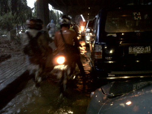
Motorists fought against flood, originally uploaded by Deden Rukmana.
Interestingly, this year’s floods in Jakarta inundated more areas than last year’s floods despite a lower level of rainfall. This year’s flood also killed at least 2 people and displaced more than 1,700 in Kampung Melayu, Bukit Duri and Bidaracina areas from overflowing Ciliwung river (The Jakarta Post, February 13, 2010 and February 20, 2010).
In the aftermath of the annual floods in Jakarta, which always occurred in the month of February, the government has been always focusing on releasing floodwater as fast as possible into the sea, particularly on the development of the East Flood Canal. The project was launched in the aftermath of the major floods in 2002 and has progressed very slowly due to the complicated process of land acquisitions. The project finally reached the sea on December 31, 2009, but there are still unfinished works in several spots. In the aftermath of this year’s flood, the government planned to connect Ciliwung River to Cipinang River which is now attached to the East Flood Canal.
The East Flood Canal has been considered as the most feasible solution for preventing future floods in Jakarta, but it clearly cannot prevent the flooding entirely. The East Flood Canal, along with dredging the rivers to enable water to flow properly, is only able to mitigate the impact of the flooding. We have also witnessed an effective flood warning system in this year’s floods in mitigating the impact of the floods.
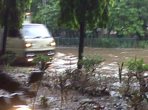
Road of flood, originally uploaded by Deden Rukmana.
Jakarta needs bold moves for preventing future flooding. Rapid urbanization in Jakarta must be reduced. A possible way of reducing urbanization in Jakarta is to redistribute the central functions of Jakarta to other parts of the nation and strengthen other urban agglomerations in Indonesia to pull urban growth away from Jakarta. The idea of Indonesian capital relocation out of Jakarta needs to be strongly reconsidered.
Water catchment areas, green areas and wetlands that have been converted into urbanized areas need to be re-functionalized as non-urbanized areas. An exemplary model of this reconversion is a decision of the Jakarta administration to convert 27 gas stations in five districts in Jakarta into green areas in November 2009. The closure of these gas stations will add another 10,505 square meters of green areas in Jakarta. This is a bold move of the Jakarta administration in expanding the green areas in Jakarta. Such a move needs to be replicated and expanded to other areas in Jakarta. Currently, green areas in Jakarta account for less than 10 percent of the city’s area, far below the target of 30 percent set by the Spatial Planning Law 26/2007.
The 2030 Jakarta spatial plan, an important and comprehensive document for shaping the next 20 years of Jakarta, is now in the making. The bold move of expanding the green areas in Jakarta needs to be strongly considered in the 2030 Jakarta spatial plan. The cost of converting urbanized areas into green areas will be expensive, but such a sacrifice is needed for the future of Jakarta, including preventing future floods.
(This article also appeared at The Jakarta Post on March 20, 2010)


1 comment:
Recently I stayed with a family in Kayu Putih in East Jakarta. They've been flooded twice in three years. It's been very difficult for them coming on top of the impact of Global Economic Crisis.
As someone with long standing interests in both Indonesia and Urban Development I'm pleased to have found your Blog. I wrote a little on floods and equity while I was in Jakarta during January. You can read this at:
http://maximos62.wordpress.com/2010/01/03/jakarta-thoughts-on-supermarkets-floods-cost-of-living/
Post a Comment