Friday, March 23, 2007

Jakarta as Indonesia's Primate City

Primate city is a major city that plays dominant role in many respects in a country. It becomes a high concentration of urban population and plays as political, economical, cultural and transportation center of a nation. In term of population, a primate city is at least twice as populous as the second largest city in the nation. For some scholars, the population of primate city is larger than a combined population of the second, third and fourth largest cities of a nation.

Is Jakarta the primate city of Indonesia? The answer is very clear. Jakarta is indeed the primate city of Indonesia. Jakarta and its peripheral areas are more than twice as populous as Bandung -the second largest city in Indonesia. The Metropolitan Jakarta's population in 2005 was 14.0 million and it is 3.4 times of Bandung's population (4.1 million). The combined population of Bandung, Surabaya and Medan -the second, third and fourth populous cities in Indonesia respectively- was 9.4 million and it was still less than Jakarta's population.

Under the Dutch colonialism, Jakarta was the center of commercial and transportation hub of the nation for three centuries. The concentrated urban activities in Jakarta had allowed the Dutch colonialist to efficiently collect the resources from across the nation or redistribute goods and services to other parts of the nation. The concentrated urban activities in Jakarta created accumulation of wealth in Jakarta and it was not a problem for the Dutch colonialist. Regional imbalance between Jakarta and other parts of the nation did not really matter for the Dutch colonialist.

The Jakarta's dominance in the Indonesia's urban system has not changed much in post-colonialism era. Data of urban population in Indonesia since 1950 as reported by the United Nations World Population Prospect (1996) reveals that the domination of Jakarta over other cities in Indonesia has been increasing since the 1950s. The highly concentrated urban activities in Jakarta indicates that the Government of Indonesia has underinvested in interregional transport and telecommunications which favors producer and investors in Jakarta over other parts of the nation. More over, Henderson (2003) asserted that favoritism involved restrictions in capital and export/import markets, all favoring firms that locate in Jakarta. This allowed the central bureaucrats and politicians not to compete with lower ranked bureaucrats from other parts of the nation for extracting rents in the allocation of loans and licences.

Regional imbalance does matter in the post-colonialist era in Indonesia. A variety of policies have been implemented to boost the development in other parts of the nation particularly the Eastern Indonesia. Even, there has been a ministry that is assigned to accelarete the development in the Eastern Indonesia. It is really hard task to do since Jakarta is still dominant in Indonesia's urban system.


The urban population data seems to indicate Bandung as a competitor for Jakarta. During periods of 1980-1985 and 2000-2005, the growth of Bandung's population surpassed the growth of Jakarta's population. Nonetheless, it is important to note that Bandung is only 160 kilometers away from Jakarta and it is like "weekend bedroom" for Jakarta residents. The highways connecting Jakarta and Bandung allow Bandung residents to commute to Jakarta. In the long term, it is not impossible that Bandung and Jakarta will be merged into one metropolitan.

More interestingly, the implementation of regional autonomy law in 1999 has not taken much effect in the urban population distribution. The regional autonomy law which is also to stimulate more growth in local level apparently could not redistribute growth from Jakarta to other parts of the nation.

Using data of many countries, Henderson (2003) found that the degree of urban concentration rather than urbanization contributes to economic growth. He asserted that over concentration will be very costly to economic growth of the country. In order to avoid the decline of economic growth due to high degree of urban concentration, the increasing dominance of Jakarta over other cities in Indonesia should be reduced. There must be other urban agglomerations in Indonesia that compete with Jakarta and reduce the degree of urban concentration in Indonesia. It will eventually create regional balance and more sustainable development in Indonesia.

References:
  1. The United Nations. (2006). The United Nations World Population Prospects
  2. Henderson, Vernon. (2003). The urbanization process and economic growth: The so-what question. Journal of Economic Growth 8:47-71
(This post was cited in a book titled Focus on Gamelan Music of Indonesia by Henry Spiller)

Tuesday, March 13, 2007

Growth of Jakarta and Suburbanization in Jakarta's Peripheral Areas


In the aftermath of the recent floods in Jakarta, the high level of urbanization was blamed as one of the culprits in the disaster that caused environmental destruction in Jakarta’s peripheral areas which were supposed to be water catchment areas. How high was the level of urbanization in Jakarta? How did urbanization cause the reduced water catchment areas in Jakarta’s peripheral areas? Before answering those questions, it is important to know what urbanization is.

The term of urbanization refers to the proportion of total population that lives in urban area. There is common mistake of thinking of urbanization as simply the growth of cities. We need to distinguish between urbanization and the growth of cities. Urbanization is a change that has a beginning and an end, but the growth of cities has no inherent limit.

Jakarta is a fully urbanized area. Since the 1990 Census, the Statistics Indonesia (BPS) determines all parts of the Jakarta’s jurisdiction are urban area. In the context of urbanization, Jakarta has come to the end. On the other hand, the growth of city which is commonly misunderstood as urbanization is still occurring in Jakarta. The growth of Jakarta has generated suburbanization in Jakarta’s peripheral areas.

Not only is Jakarta the capital of Indonesia, it is the economic, commercial and transportation hub of the nation. The Indonesia’s economy has been growing at a robust pace of 6 percent a year and Jakarta has been Indonesia’s primary growth machine. The growth of Jakarta has generated the land conversion to urban area in the Jakarta’s neighboring areas. The growth occurring in Jakarta creates the demand for housing and other urban services in Jakarta’s neighboring areas. The growth of Jakarta causes suburbanization in Jakarta’s neighboring areas. The periphery of Jakarta which was previously non-urban areas converts to urban areas in order to accommodate the growth of Jakarta. Lots of converted areas were areas which were supposed to be water catchment areas.

In the last two decades, the growth of Jakarta’s population is slower than that of Indonesia’s population. The total population of Jakarta even dropped from 9,112,652 in 1995 as recorded by the 1995 National Intercensal Population Survey to 8,361,079 in 2000 according to the 2000 Census. The decrease of Jakarta’s population in 1995-2000 was caused by the suburbanization and the slow economic growth due to the 1997 economic crisis. On the other hand, the periphery of Jakarta has experienced a drastic increase in population. The population in the periphery Jakarta has tripled from 4.4 million in 1980 to 12.6 million in 2000, while Jakarta’s population increased by only 30 percent. The Jakarta’s population back up to 8,860,381 in 2005 after a number of apartment complexes were built in Jakarta that bring back the residents live in the central city.

The growth of Jakarta is the cause of suburbanization in Jakarta’s peripheral areas. The higher economic growth of Jakarta the higher pressure in Jakarta’s peripheral areas to suburbanize. As long as Jakarta still becomes the primary growth machine of the nation the economic growth of Jakarta will be strongly associated with the pace of Indonesia’s economic growth and will correspond to the suburbanization in Jakarta’s neighboring areas. One way of reducing the pressure of suburbanization in Jakarta’s peripheral areas is to relocate the source of Jakarta’s growth. The idea of relocating the nation’s capital out of Jakarta as supported by some candidates of Jakarta’s governor is one way to reduce the suburbanization in Jakarta’s peripheral areas.

In addition, the suburbanization of Jakarta’s peripheral areas was generated by the influx of migrants from other parts of the nation particularly from poor regions of Java Island. During 1995-2005 the average number of migrants who migrated to neighboring areas of Jakarta was 1.6 million people a year. Poverty in rural areas in Java Island became a factor that pushed people from rural areas to move to urban areas. The rural poor migrate to urban area as a way of escaping from the poverty. There is inextricable link between rapid suburbanization in Jakarta’s peripheral areas and poverty in Java’s rural areas.

Wilmar Salim provided a very interesting analogy between rural poverty and urban agglomerations in Java. He identified urban agglomerations as lotuses and rural poor as those who need a base for escaping from poverty. He raised critical question of how long will the lotuses be able to stay afloat and suggested several policy for alleviating rural poverty.

Below is some excerpts of his article that appeared in the Jakarta Posts on December 22, 2006:

... Moreover, 12.5 million (57.9 percent) of the poor in Java live in rural areas. In other words, the poor are concentrated in rural areas, and 32 out of 100 poor Indonesians lived in rural Java in 2000. Though the current figures are unknown, we can guess that they are similar.

What was not really discussed in either report was the spatial distribution of the poor in Java. Poverty mapping conducted by SMERU Research Institute (2004) showed that poverty enclaves were created in areas far from urban agglomerations, such as Jabodetabek, Bandung Raya or Gerbangkertosusila (Surabaya Metropolitan Area). The southern part of Banten and West Java, the central part of Central Java, the south-west and south-east parts of East Java, and the island of Madura were areas with high concentrations of poor in 2000.

At the same time, the growth of Javanese cities shows conflicting patterns between the census in 1990 and 2000. Some of these cities, especially those in the above agglomerations, experienced positive or even rapid population growth. But some, i.e. Surakarta, Yogyakarta, Magelang, Kediri and Madiun, experienced a negative growth, or in other words, lost some of their populations. A closer look at the distribution of the poor reveals that cities that have positive or rapid growth tend to be surrounded by subdistricts with less poor populations.

Thus, the poverty situation in rural areas surrounding cities in Java is better than in more remote areas far from cities. This explains why the growth rate in big cities in Java is so great, since these cities are like lotuses that provide a base for the poor to get out of poverty. The catch is if we are not looking into rural conditions, how long will these lotuses be able to stay afloat?

The above phenomenon reflects a condition that Niles Hansen in the 1970s described as urban crisis caused by extreme poverty in rural areas due to unbalanced development. Thus, regional development policies must be enacted to balance development and ease the crisis. The bottom line is that state intervention is needed to invest in measures to support productive sectors in remote rural areas, and also increasing attention must be paid to small and medium cities.

Policies to balance development in Java can be threefold: First, control development expansion in major urban agglomerations so they will not overheat. The government will not be able to really slow down development in these cities, but it can reallocate its public investments to other areas.

Second, optimize investments that support economic activities in small and medium cities, and promote a friendly climate for private investment. Infrastructure development that supports production, such as electricity and telecommunications, needs to be intensified. Furthermore, commercial centers in the small and medium cities must be revitalized.

Third, maximize public investments in social overhead capital in areas remote from cities, and try to encourage economic activities in these areas by improving access to economic resources for villagers...


(This article also appeared at The Jakarta Post on March 27, 2007 and then it was linked at The Center of Southeast Asian Studies of Xiamen University, China and at The Development from Disasters Network)

Saturday, March 3, 2007

Capital Relocation: Lessons from Tasikmalaya and Riau Islands

In this post, we have two commentaries from my fellows: Miming Miharja and Fajar Hari Mardiansyah concerning their experiences of capital relocation projects. I am pleased to have their commentaries that give us some perspectives regarding the idea of Indonesia’s capital relocation.

Miming Mihardja is a faculty member of the School of Architecture, Planning and Policy Development, Bandung Institute of Technology. His comment was from his experience when he led a team of LAPI of Bandung Institute Technology a few years ago. His team investigated a new location for the capital of Tasikmalaya Regency (Kabupaten Tasikmalaya) . Tasikmalaya Regency is one of regencies in West Java province and needed to relocate its capital because the old capital was then located in new municipality, the city of Tasikmalaya (Kota Tasikmalaya) that was split off from Tasikmalaya Regency in 2001.

His case shows the challanges faced by his team in the selection process of new capital location. The case confirms that the capital relocation is highly political process. He asserted that even in local level, the political tension among different stakeholders was very high. The public hearings that were intended to accomodate the citizen participation put the team on edge. I fully agree with him that the case of the nation capital relocation would be more complicated than the regency capital relocation. Indeed, not to mention the cost of relocation.

Other thing that amazes me is rationality is not in demise. Using technical argumentation, the team was able to convince different stakeholders of the proposed location of new capital. It should be a case demonstrating stakeholders' trust in the expert team. Many scholars argue that the post-modern era characterized by fragmented power, distrust of government and experts, and incommensurable discourse leads to the demise of modernist planning practice in which rationality is one of the important premises. The case of Tasikmalaya regency's capital relocation shows the high political tensions in the planning process but the political stakeholders still have trust in the expert.

Miming's comment also brings up the issue of the cost of relocation. One interesting thing is the possible choice of private sector to finance the cost of relocation. I absolutely agree with this possible choice. Private finance instead of public finance. However, we should discuss it separately in other post ...

Below is the completed comment from Miming Mihardja:

Reflection from a local experience, when I was the LAPI-ITB acting team leader of Tasikmalaya Regency capital relocation in 2001. This case to some extent represents the socio-economic- political characteristic of our nation capital relocation topic of discussion.

First of all, we experienced a complicated and painful process during the location selection stage. This stage is a highly political game for many interest groups contributed as well as distorted the process. I learn a lot, that the Patsy Healey's collaborative planning, Tore Sager's communicative planning etc. are not only complex in theory, but far more complex in application, especially in our young-democratic country where euphoria is a fact that neglect every public planning process. I remember that to survive public hearing attended by many self (or selfish)-motivated stakeholders is a high-challenging moment i have to went through several times. Thank God i survive. Many times we had to face the strong opposed debate to our technical justification. Sometimes the argument simply came from the local sentiment feeling, just to fight for their own municipality's candidacy without clear justification. I learn a lot that strong technical argumentations often saved our proposed location. So, engineering approach is still useful in that case.
 
The study finally chose Singaparna-Mangunre ja municipalities as the selected new capital. The existing condition of the candidates are in the very early stage of development, especially in terms of basic infrastructures which are no doubt the substantial needs for a capital.

As we can easily imagine, the budget issue is definitely the other main constraint or limitation to be said more straightly. We estimated a number of trillion rupiahs for the development which was very far from local budget capability. Some higher tier government financial aid were identified, but still far from enough. The solution promisingly came from private investors. However, this last alternative generates high economic-political cost due to our clienty style of governance. This limitation implies the prolonged execution of the plan, despite the readiness of the physical plan our team prepared.

Talking about Indonesia new capital..... . You may multiple my story by 100, 1000, i don't know, you just mention it....

Just to mention that we should still proud of planner, our team succeeded in settling down the turbulence in the location selection process. Now, Regency Tasikmalaya has the widely accepted new capital together with its physical plans. The execution of the plan is their next challenge... .

Fajar Hari Mardiansyah is a faculty member of the Department of Regional and City Planning at Diponegoro University, Indonesia. He was a member of team that investigated the location of Riau Islands Province’s capital. Riau Islands Province is originally parts of Riau province that was split off as a separate province in 2004. He needed to leave the team before the project was completed and left for Paris to pursue his doctorate degree in the University of Paris.


Fajar’s story confirms Miming’s story that the selection process of capital location is highly political process. Technical argumentation from the team was not easily accepted by the parliament. Interesting interpretation from this story is the vested interests of some parliament members may be the reason of opposing the technical argumentation. Distrust of experts is rooted from the vested interests. Indeed, it is saddening and is a big challenge for developing democracy in Indonesia.

Below is the completed commentary from Fajar Hari Mardiansyah:

My experience in a project of location selection for the capital of Riau Islands Province was much rather a selfish-economic-interest of the major group of the political leaders in the province, especially in the provincial parliament,
rather than a socio-politic aspects. The well-technically recommended location had to struggle hardly to the demands of the majority of the parliament members who had done a speculation for some majority parcels in a certain location that they recommend to be the location of the capital. They did it with an assumption that they are the majority stakeholders in the decision process. But the problem was they never tell the true reasons meaning they have speculated in the location they preferred but arguing without unclear justifications when they rejected the better technical-based recommendation. Many arguments, ranging from the history of the location, the acceptance of the community members who owned the land, the close distance to the previous city, etc had been raised by them to cover the true that the most of the land had been owned by themselves.

Technical explanation countering their arguments of what they think they are good is not quiet good enough in the implementation part of the development seemed to be non-sense for them. Many dead-locks happened in the discussion just because theair of the discussion that seemed to me as a situation of a 'demokrasi pokoknya', that means every body can speak and tell his/her opinion but their position will never change. Later, the number of dead-locks was the main reason for the postponed of the process in order to give some time to the technical team to lobby some parliament members. Unfortunately, I don't know the later story because I had to begin my French preparation course for my current study. Is the decision has been made? Which location that is chosen? Frankly I am really curious about it.And the most importantly, how the decision process was finally completed (if the decision has been taken) is the one that I really want to know.

Looking to this experience, I am sure that the conflict of interest in selecting the new location of the capital of the Republic of Indonesia will be very... very... very... far bigger (this is the French culture to mention a huge of something by telling 'un tres...tres..tres.. grand problem', for example), than the selection of the capital of Riau Kepulauan. Especially the conflict of the selfish-interest of the economic players who collaborate to the political players. I just hope that the location is not in Java if we want to move our capital. It can be used also to make a more balance regional development in the country. Somewhere in the central or the North Sumatera, I think, will be my preference, then the next 50 years it will move again to Sulawesi. A planner or a dreamer am I....?

Thursday, March 1, 2007

Jakarta: From Global City to Ailing City

The modern city of Jakarta was initiated by President Soekarno who has strong vision to build Jakarta into the greatest city possible (Cybriwsky and Ford, 2001). He gave Jakarta Monas –his most symbolic new structure of 132 m high national monument, spacious new government buildings, department stores, shopping plazas, hotels, sport facilities of Senayan that was used for the 1962 Asian Games, the biggest and most glorious mosque of Istiqlal, new parliament buildings and waterfront recreation area at Ancol.

Such constructions continued under the New Order regime that began in 1967. In the early administration of this regime, some projects were completed including the Ismail Marzuki Arts Center, industrial zones at Tanjung Priok and Pulo Gadung that aimed to attract foreign investment, and the unique theme park of Taman Mini Indonesia Indah.

During thirty-two years of the New Order regime, Jakarta has changed considerably. A generally rapid economic growth during this period allowed Jakarta to expand its modern constructions and develop a modern city. Firman (1998; 2004) noted that the physical development of Jakarta was resulted from its functions as a “global city” in Asia. The “global cities” in Asia include Tokyo, Seoul, Taipei, Hongkong, Manila, Bangkok, Kuala Lumpur, Singapura and Jakarta. Hundreds of new office towers, hotels and high-rise apartment-condominium building were built in many parts of the city.

In a recent article, Murakami and her colleagues (2005) compared the urbanization stage and patterns of land use in Jakarta, Bangkok dan Manila. Using the Clark linear exponential model and the Newling quadratic exponential model, they compared the spatial distribution of population densities in those cities. They also analyzed land-use patterns by examining the mixture of urban and agricultural land use. They found that Jakarta has entered the suburbanization stage, while Manila was at early stage of suburbanization and Bangkok was at intermediate stage of suburbanization.

The Golden Triangle –a new style commercial zone- was built in Thamrin-Sudirman corridor to push the urban skyline upward in response to high costs of land in key areas and the convenience of the automobile (Cybriwsky and Ford, 2001). This zone was aimed to accommodate internationally invested high-rise mega-blocks. This was a result of regional competition among “global cities” (Firman, 1998; Goldblum and Wong, 2000). Jakarta is linked with other “global cities” in a functional system built around telecommunications, transportation, services and finance.

A parade of tall buildings one after the other filled the major streets on both sides. They house the offices of Indonesian and multi-national corporations. Firman (1999) reported that total area of commercial space in Jakarta in 1978 was only 0.1 million square meters and in 1997 it reached 2.7 million square meters with nearly 90 percent of occupancy rates. In every parts of the city, modern shopping malls along with family enterprises were also built.

The economy crisis which hit Indonesia 1998 resulted in major disruptions on urban development in Jakarta. Such monstrous crisis has shifted Jakarta from “global city” to “city of crisis”. The crisis –commonly known in Indonesia as krismon- had largely squeezed the economy of Jakarta. Domestic and foreign investment dramatically declined. Many manufacturing and services corporations in Metropolitan Jakarta closed and laid off their employees, resulting in rapid increase of open unemployment.

In order to survive amidst the krismon, a large number of workers had shifted to become food traders or engaged in other informal sector jobs. Street vendors –commonly known in Indonesia as pedagang kaki lima- increased rapidly from about 95,000 in 1997 to 270,000 in 1999 (Firman, 1999). Increasing informal labor force is a distinctive characteristic of cities in developing countries since sector formal can not accommodate the large number of labor force.

The shrinkage of economic activities resulted in the decrease of office space demand. It dropped from 300,000 square meters in 1997 to 85,000 square meters in 1999. Similarly, the demand for high-class apartments dropped from 49,000 in December 1997 to 16,000 in February 1998. The housing market in Metropolitan Jakarta nearly collapsed due to increasing prices of building materials and housing loan interest rates. Most construction projects in the periphery of Jakarta slowed down or even completely stopped (Firman, 2004).

Firman (2004) argued that in the near future after the krismon, urban poverty was the most obvious issue on urban development in Jakarta. This includes job creation, basic need provision for the poor, improvement of living environment in slums areas and micro credit provision with low interest.

In order to mitigate the impact of the krismon, the government along with the assistance of IMF launched a variety of social safety net programs in July 1998. The programs include food security, employment creation, scholarship to students and block grants to schools, targeted health care subsidies, and community block grant (Sumarto, et. al., 2004). Political and economic reforms were also implemented during the recovery process.

Firman (2004) reported that by 2002 there were about three-fifth of the new town projects in the fringe areas of Jakarta still survived. The remaining was no longer in operation or terminated the projects due to the economic crisis. More than 450 developers went out of business during the krismon.

Civil unrest and political uncertainty that heightened during the krismon reduced gradually during the recovery process. As of early 2007, Indonesia’s economic performance is more positive. In the last two years, Indonesia's economy has growing at a robust pace of 6 percent a year. As the capital and the center of economic, commercial and transportation hub of the nation, Jakarta has secured as the primary growth machine and has been recovering from the krismon.

While Jakarta is still not fully recovered from the krismon, the recent floods retard the recovery process. The flood which was blamed as the result of unsustainable development process in Jakarta and its extented region remind us that Jakarta is an ailing city. She needs major remedy for her illnesses to get back to be global city.

References:

  1. Cybriwsky, Roman and Ford, Larry R. (2001). City profile: Jakarta. Cities 18(3): 199-210.
  2. Firman, Tommy. (1998). The restructuring of Jakarta Metropolitan Area: A “global city” in Asia. Cities 15(4): 229-243.
  3. Firman, Tommy. (1999). From “global city” to “city of crisis”: Jakarta Metropolitan Region under economic turmoil. Habitat International 23(4): 447-466.
  4. Firman, Tommy. (2004). New town development in Jakarta Metropolitan Region: A perspective of spatial segregation. Habitat International 28(3): 349-368.
  5. Goldblum, Charles, and Wong, Tai-Chee. (2000). Growth, crisis and spatial change: A study of haphazard urbanization in Jakarta, Indonesia. Land Use Policy 17: 29-37.
  6. Murakami, Akinobu, Zain, Alinda Medrial, Takeuchi, Kazuhiko, Tsunekawa, Atsushi, and Yokota, Shigehiro. (2005). Trends in urbanization and patterns of land use in the Asian mega cities Jakarta, Bangkok, and Metro Manila. Landscape and Urban Planning 70: 251-259.
  7. Sumarto, S., Suryahadi, A. and Widyanti, W. (2004). Assessing the impact of Indonesian social safety net programs on household welfare and poverty dynamic. SMERU Working Paper


(This article also appeared at Urbanicity's City Matters Magazine on March 2007)

Urbanization and Suburbanization in Jakarta

Jakarta is the largest metropolitan in Southeast Asia with tremendous rate of population growth and wide range of urban problems. The overall population of Jakarta increased 100 times in the 20th century, from about 100,000 in 1900 to more than 9 million in 1995. Most of the population was added in the last twenty years of the 20th century (Han and Basuki, 2001). However, the total population of Jakarta has decreased in the last five years of the last decade. It dropped from 9,112,652 in 1995 as recorded by the 1995 National Intercensal Population Survey to 8,389,443 in 2000 according to the 2000 National Population Census.

The decrease of Jakarta’s population in 1995-2000 was caused by the suburbanization. The periphery of Jakarta –commonly known as Botadebek- has experienced a drastic increase in population. The population of Botadebek has tripled from 4.4 million in 1980 to 12.6 million in 2000, while Jakarta’s population increased by only 30 percent. Some studies (Firman, 1998; Leaf, 1994; Cybriwsky and Ford, 2001) revealed that many moderate and high-income families moved out from the central city to the peripheral areas. They were attracted by high quality amenities provided by suburban enclave housing. In addition, the poor native Jakarta was relocated to the fringe areas because of the expansion of formal sector in the central city.

Total population of the Jakarta Metropolitan Area consisting of Jakarta and the neighboring districts of Bogor, Tangerang, Depok and Bekasi –abbreviated as Botadebek- in 2000 reached more than 21 million. This population consisted of about 80 percent urban population and 20 percent rural population and inhabited an area of approximately 6400 square kilometers. This population was about 10 percent of total population of Indonesia and only about 0.3 percent of total area of Indonesia. McGee (1994) estimated that the total population of the Jakarta Metropolitan Area will reach 40 million by 2020.

The periphery of Jakarta is heavily dependent on the central city. Botadebek is a “bedroom suburb” for the daily commuters of Jakarta. Jakarta is the center of government and corporate offices, commercial, and entertainment enterprises. The economy of Jakarta dominates its peripheral areas. In the daytime, total population in Jakarta nearly doubled its population in the nighttime (Kompas, June 18, 2004). The number of daily movement in Jakarta is estimated at six to seven millions

To understand the urbanization in Jakarta, it is essential to recognize the socio-economic dualism which pervades Indonesian urban society. The manifestations of this dualism are the presence of the modern city and the kampung city in urban areas in Indonesia including Jakarta. The kampung, the word means village in Indonesian, is associated with informality, poverty, and the retention of rural traditions in an urban setting. Firman (2000) argues that the existence of kampung and modern city reflects the spatial segregation and socio-economic disparities.

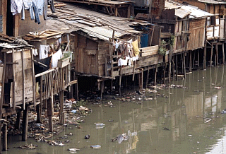
The growing number of migrants to Jakarta and of poor Jakarta natives has caused the formation of new squatter kampungs in the periphery of Jakarta (Cybriwsky and Ford, 2001). Many constructions in the central city also caused some residents of kampung evicted and relocated to the periphery. The periphery also attracted the migrants because of the improved infrastructure and facilities in Jakarta’s peripheral areas (Goldblum and Wong, 2000).

Since 1950 Jakarta has attracted people from all parts of Java and other Indonesian islands. The flood of migrants came to Jakarta for economic reasons as Jakarta offered hopes of jobs. The census 1961 showed that only 51% of the city’s populations were actually born in Jakarta (Cybriwsky and Ford, 2001). Several times the Jakarta officials tried to control the migration by declaring the city to be a closed city where new migrants were not allowed. However, these attempts were useless since the large number of migrants ignored the laws.

Leaf (1994) identified rapid growth of suburban enclave housing in Jakarta during early 1990s. The residential enclave for narrowly targeted moderate and high-income families characterized the Jakarta’s suburban (Firman, 1998; Leaf, 1994). Located on the periphery of the city, these settlements were built in automobile-accessed and various high-quality amenities such as modern golf courses. High-income families in the central city also moved to the periphery in search of better living quality (Goldblum and Wong, 2000). The high cost of the house and the need for automobile ownership restricted entry low-income families into the suburban housing market. One in five families in Jakarta’s suburban owned an automobile (Leaf, 1994).

Leaf (1994) argued that the suburbanization in Jakarta was direct outcome of at least two policies: the subsidized housing finance program and municipal permit system for land development. These policies have most benefited some developers that strongly linked with the New Order regime. Half of the land development permits were given to 16 out of 183 development firms (Leaf, 1994).

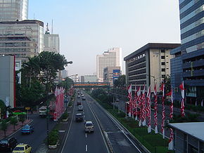
In addition to residential zones, the periphery of Jakarta is also specialized zones of commercial and industrial enterprises. There areas are complements the other districts of the city: the central business districts on Thamrin-Sudirman corridor, the government offices around Medan Merdeka, international seaport of Tanjung Priok, and the growing network of freeways. Initiated by a collaborative project of Bumi Serpong Damai in the early 1980s, the periphery of Jakarta was also location of several new towns. The first new town of Bumi Serpong Damai was planned for an eventual population of 600,000 in a total area of 6,000 hectares. This project was developed by several private developers and lead by the largest private developers –the Ciputra Group. Other new towns in the periphery of Jakarta include Bukit Jonggol Asri, Pembangunan Jaya, Lippo City, Cikarang Baru, Tigaraksa, Kota Legenda, Kota Cileungsi, Royal Sentul, Bintaro Jaya, Lido Lakes Resort, Gading Serpong, Modernland, Kot Citra Raya, Alam Sutera dan Kedaton (Firman, 1998).

In a number of new towns, the State Housing Provider Agency (Perumnas) joined with private developers to assure that some of their housing was targeted for low and moderate-income families (Cybriwsky and Ford, 2001). Most of the new towns offer relatively few employments. Their initial concepts to create self-contained communities are barely implemented. Instead, the new towns are “bedroom suburbs for city-bound commuters” (Cybriwsky and Ford, 2001).

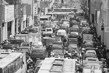
The new towns were still heavily dependent on the central city (Firman, 2000). The development of large-scale housing projects intensified the daily interaction between the fringe areas and the central city of Jakarta. This worsened traffic problems in metropolitan Jakarta. The development of industrial zones in the periphery of Jakarta is also an indication of spatial restructuring that shifted manufacturing from the central city to the periphery. Using data of domestic and foreign investment in various economic sectors in Jakarta and its peripheries (Bogor, Tangerang and Bekasi), Firman (1998) found that the central city has attracted disproportionate investment in service industries, trade and hotel, and restaurant construction, while the peripheries has attracted most of the industrial construction. The main industries of Jakarta’s periphery include textiles, apparel, footwear, plastics, chemicals, electronics, metal products and foods (Cybriwsky and Ford, 2001).

As the capital and the economic, commercial, cultural and transportation hub of Indonesia, Jakarta and its extended areas willl remain attract growth. The urbanization and suburbanization in metropolitan Jakarta will keep going on. The predicted metropolitan Jakarta by the United Nations Population Prospects in 2015 will account for 7.2 percent of Indonesia's population. It grew from only 6.3 percent and 4.4 percent of Indonesia's population in 2005 and 1985 respectively.

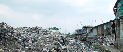
Will Jakarta and its extended areas be able to accomodate urbanization and suburbanization? Will Jakarta sustain its growth? I doubt it. As I mentioned in earlier post, the recent floods is strong evidence to reduce urbanization in Jakarta. The flood is only one of other many evidences including traffic congestion and urban poverty. The on-going urbanization and suburbanization in Jakarta will create more problems not only for Jakarta but also for Indonesia.


Reference:

  1. Cybriwsky, Roman and Ford, Larry R. (2001). City profile: Jakarta. Cities 18(3): 199-210
  2. Ernst, John P. (2004). Initiating bus rapid transit in Jakarta, Indonesia. A paper presented to the 2004 TRB Annual Meetings.
  3. Firman, Tommy. (1998). The restructuring of Jakarta Metropolitan Area: A “global city” in Asia. Cities 15(4): 229-243.
  4. Firman, Tommy. (1999). From “global city” to “city of crisis”: Jakarta Metropolitan Region under economic turmoil. Habitat International 23(4): 447-466.
  5. Firman, Tommy. (2004). New town development in Jakarta Metropolitan Region: A perspective of spatial segregation. Habitat International 28(3): 349-368.
  6. Goldblum, Charles, and Wong, Tai-Chee. (2000). Growth, crisis and spatial change: A study of haphazard urbanization in Jakarta, Indonesia. Land Use Policy 17: 29-37.
  7. Han, Sun Sheng and Basuki, Ann. (2001). The spatial pattern of land values in Jakarta. Urban Studies 38(10): 1841-1857.
  8. Leaf, Michael. (1994). The suburbanization of Jakarta: A concurrence of economics and ideology. Third World Planning Review 16(4): 341-356.
  9. McGee, T. (1994). The future of urbanization in developing countries: the case of Indonesia. Third World Planning Review 16: iii-xii.