Suburbanization in Asia: A focus in Jakarta
This post is one of the chapters in the book titled "The Routledge Companion to the Suburbs" edited by Bernadette Hanlon and Thomas J. Vicino. The book was published by the Routledge in September 2018. You can find the book in the Routledge link here. The chapter on Jakarta was written by Fikri Zul Fahmi, Tommy Firman and myself. Tommy Firman is professor of Regional Planning at the Bandung Institute of Technology and Fikri Zul Fahmi is assistant professor of Urban and Regional Planning at the Bandung Institute of Technology, Indonesia.

Suburbanization in Asia: A focus in Jakarta
By Deden Rukmana, Fikri Zul Fahmi and
Tommy Firman
Introduction
Jakarta is the capital of Indonesia and the
largest metropolitan area in Southeast Asia with tremendous population growth,
land use change and new town and industrial estate development. The overall
population of the Jakarta region grew in the 20th Century, from about 150,000
in 1900 to about 30 million in 2014. The metropolitan region of Jakarta is also
called Jabodetabek, taken from the
initial letters of the administrative units of Jakarta, Bogor, Depok, Tangerang
and Bekasi. The center of Jabodetabek is
Jakarta, also called the Special Capital Region of Jakarta (Daerah Khusus Ibukota Jakarta) and
covers a total area of 664 square kilometers. The inner peripheries of the metropolitan
region of Jakarta include four municipalities (City of Tangerang, City of South
Tangerang, City of Depok, City of Bekasi), whereas the outer peripheries of
Jabodetabek include the City of Bogor, Tangerang Regency and Bekasi Regency. The metropolitan region of
Jakarta covers a total area of 5,897 square kilometers (Hudalah and Firman 20011).
Jakarta, or the Special Capital Region of
Jakarta, has ‘provincial government level’ status. The peripheries of
Jabodetabek are within the jurisdiction of two provinces. The City of Bogor, City of Depok, City of Bekasi
and Bekasi Regency are within the jurisdiction of West Java Province, whereas
the City of Tangerang, City of South Tangerang and Tangerang Regency are within
the jurisdiction of Banten Province. The four municipalities within the inner
peripheries of Jabodetabek are new municipalities founded in the 1990s and
2000s. The City of Tangerang, City of Bekasi, City of Depok and City of South
Tangerang were founded in 1993, 1996, 1999 and 2008 respectively. The City of
Tangerang and City of South Tangerang seceded from Tangerang Regency.
Meanwhile, the City of Depok was part of Bogor Regency and the City of Bekasi
seceded from Bekasi Regency.
This chapter will examine
the extent to which the Jakarta region has transformed from a concentric and
radial pattern urban structure to an early stage of post-suburbanization with
an emerging fragmented structure of peripheral areas. The evolution of new
towns and industrial estates in the peripheries of the Jakarta region will be
discussed. The chapter will focus on the nature of suburban growth in the
Jakarta region and the policies and plans to contain or influence patterns of
the suburbanization.
Population Growth of the Metropolitan Region of Jakarta
Jakarta
has been the capital of Indonesia since the Dutch colonial era. The population
of Jakarta in 1900 was about 115,000. In the first nationwide census of the
Dutch colonial administration (1930), Jakarta’s population increased to
409,475. In the next ten years, the population increased to 544,823 with an
annual growth rate of 3.30%. After Independence, Jakarta increased by nearly
three times to 1.43 million by 1950. It increased to 2.91 million in 1960 and
4.47 million in 1970. The annual growth rates of Jakarta’s population are
10.35% and 5.36% (1950-1960 and 1960-1970 respectively).
Table
1 shows the population of the metropolitan region of Jakarta including
Jakarta, the inner and outer peripheries of Jakarta, from 1980 to 2010. The
Megacity of Jakarta increased from 11.91 million in 1980, 17.14 million in
1990, and 20.63 million in 2000 to 28.01 million in 2010. The megacity in 2010
was 11.79 percent of Indonesia’s total population but this population resides
in less than 0.3 percent of Indonesia’s total area. The proportions of
Jabodetabek’s population to the total population of Indonesia have steadily
increased from 8.07%, 9.56%, to 10.0% (in 1980, 1990, and 2000
respectively).
Table 1
Population of the Metropolitan
Region of Jakarta in 1980-2010
(in millions)
Area
|
1980
|
1990
|
2000
|
2010
|
Core
|
6.50
|
8.26
|
8.39
|
9.60
|
Jakarta
|
6.50
|
8.26
|
8.39
|
9.60
|
Inner peripheries
|
n.a
|
n.a
|
4.93
|
7.22
|
City of Tangerang
|
n.a
|
n.a
|
1.33
|
1.80
|
City of South Tangerang
|
n.a
|
n.a
|
0.80
|
1.29
|
City of Depok
|
n.a
|
n.a
|
1.14
|
1.75
|
City of Bekasi
|
n.a
|
n.a
|
1.66
|
2.38
|
Outer peripheries
|
5.41
|
8.88
|
7.31
|
11.20
|
City of Bogor
|
0.25
|
0.27
|
0.75
|
0.95
|
Tangerang Regency
|
1.53
|
2.77
|
2.02
|
2.84
|
Bekasi Regency
|
1.14
|
2.10
|
1.62
|
2.63
|
Bogor Regency
|
2.49
|
3.74
|
2.92
|
4.78
|
Megacity of Jakarta
|
11.91
|
17.14
|
20.63
|
28.02
|
Sources: Rukmana
(2014)
Transformation
of Jakarta
The modern city of
Jakarta was initiated by President Soekarno’s strong vision to build Jakarta
into the greatest city possible (Cybriwsky and Ford, 2001). He gave Jakarta,
Monas – his most symbolic new structure the 132 m high national monument,
spacious new government buildings, department stores, shopping plazas, hotels,
the sport facilities of Senayan that were used for the 1962 Asian Games, the
biggest and most glorious mosque of Istiqlal, new parliament buildings and the
waterfront recreation area at Ancol.
Such constructions
continued under the New Order regime that began in 1967. Under this regime,
Indonesia enjoyed steady economic growth, along with a reduction in the
percentage of the population living under the poverty line. Jakarta grew
rapidly during this period of the New Order regime. The investment in the
property sector, including offices, commercial buildings, new town development,
and highrise apartments and hotels grew substantially. Jakarta, by the
mid-1990s, was heading towards global city status. Jakarta was the largest
concentration of foreign and domestic investment in Indonesia and received US$
32.5 billion and Rp. 68,500 billion from foreign and domestic investment
respectively during the period of January 1967-March 1998 (Firman 1999).
In the early
administration of the New Order regime, some projects were completed, including
the Ismail Marzuki Arts Center, industrial zones at Tanjung Priok and Pulo
Gadung, that aimed to attract foreign investment, plus the unique theme park of
Taman Mini Indonesia Indah. During the thirty-two years of the New Order
regime, Jakarta changed considerably. A generally rapid economic growth during
this period allowed Jakarta to expand its modern constructions and develop into
a modern city. Hundreds of new office towers, hotels and high-rise condominiums
were built in many parts of the city.
The Golden Triangle – a
new style commercial zone - was built in Thamrin-Sudirman corridor to push the
urban skyline upward in response to high land costs in key areas and the
convenience of the automobile (Cybriwsky and Ford, 2001). This zone aimed to
accommodate internationally invested highrise mega-blocks; a result of the
regional competition among “global cities” (Firman, 1998; Goldblum and Wong,
2000). Jakarta is linked with other “global cities” in a functional system
built around telecommunications, transportation, services and finance. A parade
of tall buildings, one after the other filled the major streets on both sides.
They housed the offices of Indonesian and multi-national
corporations.

The economy crisis which hit Indonesia in 1998 resulted in major disruptions of the urban development in Jakarta. Such monstrous crisis shifted Jakarta from “global city” to “city of crisis”. The crisis – commonly known in Indonesia as krismon - largely squeezed the economy of Jakarta. In order to survive the krismon, a large number of workers shifted to become food traders or then engaged in other informal sector jobs. Street vendors –commonly known in Indonesia as pedagang kaki lima- increased rapidly from about 95,000 in 1997 to 270,000 in 1999 (Firman, 1999).
This shrinkage of
economic activities resulted in the decrease of office space demand which
dropped from 300,000 square meters in 1997 to 85,000 square meters in 1999. Similarly,
the demand for high-class apartments dropped from 49,000 in December 1997, to
16,000 in February 1998. The housing market in the megacity nearly collapsed
due to increasing costs of building materials and higher housing loan interest
rates. Most construction projects in the periphery of Jakarta slowed down or
even completely stopped (Firman, 2004).
In order to mitigate the
impact of the krismon, in July 1998 the government along with the assistance of
IMF launched a variety of social safety net programs. Political and economic
reforms were also implemented during the recovery process. Civil unrest and
political uncertainty heightened during the krismon gradually lowered during
the recovery process.
As of early 2005,
Indonesia’s economic performance was more positive. The rate of economic growth
of Indonesia was 5.73% per year over the period of 2004-2008. The positive
Indonesia’s economic growth resulted in an increased number of construction
projects in Jakarta including malls, apartments and office buildings. Winarso
(2010) reported twelve malls and shopping centers in Jakarta built between 2004
and 2006 including Pondok Indah Mall, Jakarta City Center, Senayan City, Cityloft
Retail, Grand Indonesia, Pacific Place, Pasar Senen, Plaza Indonesia, Blok M
Square, Shopping Center Gandaria, Kemang Village and Kota Casablanca. The land
area of malls in Jakarta increased from 1.7 million square meters in 2000 to
4.8 million square meters in 2009 (Suryadjaja 2012). Another seven malls were
built between 2013 and 2016 including Cipinang Indah Mall, The Baywalk Green
Bay Pluit, St. Moritz, Mall at the City Centre, The Gateway, Pantai Indah Kapuk
Mall and Pondok Indah Mall 3.
Jakarta has held strong
domination in Indonesia’s economy since the colonial era (Salim and Kombaitan
2009). Jakarta has been the most attractive area for both domestic and foreign
investments in Indonesia. Nearly one-fourth of total approved foreign investment
in Indonesia over the period of 2000-2005 was in Jakarta due to Jakarta’s high
concentration of skilled labor and entrepreneurs (Firman 2008).
Jakarta's contribution
to Indonesia's GDP in 2010 increased to 16.7% from 14.9% in 2000. The staggering
Jakarta's contribution to Indonesia's economy was primarily caused by the
dominance of Jakarta in the financial and business sector. The high economic
growth of Jakarta also pulled more people to move to Jakarta. Kenichiro (2015)
identified that coming back to the city as a new trend after the krismon. Such
a trend was indicated by the population growth of Jakarta over the period of
2000-2010 that was higher than that of the period of 1990-2000.
Since 2005, Jakarta
witnessed the construction of luxury high-rise apartments in many parts of
Jakarta. The investors of luxury high-rise apartments also came from several
Asian countries including China, Singapore, Hongkong and Japan (Colliers International
2017). The cumulative supply of luxury apartments in Jakarta reached more than
100,000 units by 2012 (Kenichiro 2015). The luxury apartment market in Jakarta
has been strong in the last decade. In the first four months of 2017 alone, a
total of 2,790 units of luxury high-rise apartments have been completed in
three projects including Nerine Tower, Elpis Residence and Paradise Mansion
(Colliers International 2017).
According to the
Council on Tall Buildings and Urban Habitat, Jakarta has a total of 377 tall
buildings with the minimum height of 100 meters by 2017. Jakarta ranks twelfth
among cities in the world for the number of tall buildings (CTBUH 2017). Jakarta
has a strong trend for vertical urbanism marked by the construction of numerous
high-rise buildings (Alexander et al 2016). A total of 66 high-rise buildings
are still under construction and being proposed in Jakarta including the
Signature Tower that will become the Jakarta’s tallest building in 2022.

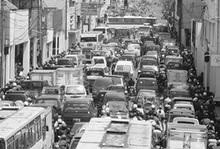
Jakarta has experienced a tremendous population growth and faced a wide range of urban problems in the last few decades. Two major problems of Jakarta are traffic congestions and floods. The urbanization and suburbanization in Jakarta are strongly associated with the traffic congestion in Jakarta. Jakarta is estimated to lose US$3.5 billion a year because of traffic congestion which can’t be separated from the high growth rate of vehicle ownership (Wismadi et al 2013). Jakarta heavily relies on road transportation and about 80% of trips made by private vehicles (Sugiarto et al 2015).
According to the
Jakarta’s Bureau of Statistics (2016), nearly three quarter (74.66%) of
vehicles in Jakarta in 2014 was motorcycles. The number of motorcycles
increased at a rate of 13.35% per year from 6.76 million in 2008 to 13.08
million in 2014. The number of passenger cars increased at a rate of 8.65% per
year from 2.03 million in 2008 to 3.27 million in 2014. Over the same period,
the total road length in Jakarta increased at a rate of 0.90% per year.
Several programs have
been implemented to alleviate the acute traffic congestions in Jakarta
including the expansion of inner-city toll road and the development of Bus Rapid
Transit (BRT) and Mass Rapid Transit (MRT). The total length of inner-city toll
road in Jakarta increased from 112.9 kilometers in 2008 to 123.73 kilometers in
2014. The BRT or popularly known as TransJakarta was introduced in 2004 and the
service of TransJakarta had been expanded to 12 corridors with a total of 669
buses by 2014. The total number of passengers of the bus rapid transit in 2014 was
111.6 million.
For at least 20 years, the proposed MRT has
been under discussion by the Jakarta administration and the government of
Indonesia. Activists and non-governmental watchdogs have seen the MRT proposal
as a possible bonanza for corrupt politicians and contractors. Eventually, the
government secured a $1.6 billion loan agreement with the Japanese
International Cooperation Agency (JICA) in 2009 for funding. The construction
of the MRT project began on October 10, 2013. The first MRT tract will connect
Lebak Bulus, South Jakarta and the Hotel Indonesia traffic circle with six
underground stations, seven elevated stations and a capacity of 173,000
passengers per day (Rukmana 2014). By June 30, 2017, the completion of the MRT
first tract was nearly 75 percent. The Jakarta city administration expected to
launch the service of MRT to the public for trial purposes in August 2018.
Jakarta lies in a
lowland area with 13 rivers. All tributaries and basin areas of these 13 rivers
are located in the peripheries of the megacity, strongly associated with the
floods in Jakarta. Industrial parks and new towns were built in the peripheries
of Jakarta and many of them have converted water catchment areas, green areas
and wetlands. Such land conversions have affected the severity of flooding in
Jakarta. Floods have become a threat and bring increasing woes for Jakarta
residents every year.
Flooding has had
critical impact on the infrastructure and population of Jakarta. In 2008,
floods inundated most parts of Jakarta including the Sedyatmo toll road; and
nearly 1,000 flights in the Soekarno-Hatta International Airport were delayed
or diverted while 259 were cancelled. In 2012, floods submerged hundreds of
homes along major Jakarta waterways, including the Ciliwung, Pesanggrahan,
Angke and Krukut rivers, and displaced 2,430 people. In January 2013, many
parts of Jakarta were inundated following heavy rain; and, as reported by the
National Disaster Mitigation Agency (BNPB), the ensuing floods killed at least
20 people and sent at least 33,502 fleeing their homes (Rukmana 2014)
In the aftermath of
these annual floods, the government normally attempts to dredge the rivers and
release floodwater as quickly as possible into the sea via the East Flood
Canal. Construction of the East Flood Canal began in the aftermath of major
floods in 2002, and reached the sea on December 31, 2009 after very slow progress
due to the complicated land acquisitions. The East Flood Canal has been
considered the most feasible means to prevent future flooding in Jakarta, but
clearly cannot prevent flooding entirely.
New
Towns and Industrial Estates in the Suburbs of Jakarta
In order to understand
the suburbanization in the metropolitan region of Jakarta, it is essential to
recognize the socio-economic dualism pervading Indonesian urban society. The
manifestations of this dualism are the presence of the modern city and the kampung
city in urban areas. The kampung, ‘village’ in Indonesian, is associated with
informality, poverty, and the retention of rural traditions within an urban
setting. Firman (1999) argues the existence of kampungs and modern cities
reflect spatial segregation and socio-economic disparities.

The growing numbers of migrants to Jakarta and poor Jakarta natives have produced new squatter kampungs on the periphery of Jakarta (Cybriwsky and Ford, 2001). Many constructions in the central city also caused some residents of kampungs to be evicted and relocated to the periphery (Silver, 2007). The periphery also attracted migrants because of its improved infrastructures and facilities in (Goldblum and Wong, 2000). Since 1950, Jakarta has attracted people from all parts of Java and other Indonesian islands. The flood of migrants came to Jakarta for economic reasons as Jakarta offered the hope of employment.
Starting in the early
1980s, agricultural areas and forests in the suburbs of Jakarta were converted
massively into large-scale subdivisions and new towns (Silver 2008). Over the
period of 1990 and 2010, more than 30 new large new towns were built in the
suburbs of Jakarta ranging from 500 hectares to 30,000 hectares. They converted
more thousands hectares of rural land (Firman 2014; Winarso and Firman 2002)
The massive development
in the suburbs of Jakarta was a result of a series of deregulation and
de-bureaucratization measures enacted by the Suharto government in the 1980s
(Winarso and Firman 2002). The subsidized housing finance program and municipal
permit system for land development also contributed to the massive development
in the area. These policies have most benefited some developers that were
strongly linked with the New Order regime (Leaf, 1994).
The residential enclave
for narrowly targeted moderate and high-income families characterized Jakarta’s
suburban area (Firman, 1998; Leaf, 1994). Located on the periphery of the city,
these settlements were built in automobile-accessible areas with various
high-quality amenities such as modern golf courses. High-income families in the
central city also moved from the city in search of better living quality
(Goldblum and Wong, 2000). The high cost of houses and the need for automobiles
restricted low-income families from the suburban housing market. One in five
families in Jakarta’s suburbs owned an automobile (Leaf, 1994).
The first new town in
the suburbs of Jakarta is a collaborative project of Bumi Serpong Damai in the
early 1980s. This first new town was planned for an eventual population of
600,000 in a total area of 6,000 hectares; a project developed by several
private developers and led by the largest private developer – the Ciputra
Group. Other new towns in the suburbs of Jakarta include Bukit Jonggol Asri, Bukit
Sentul, Pembangunan Jaya, Lippo City, Cikarang Baru, Tigaraksa, Kota Legenda,
Kota Cileungsi, Royal Sentul, Bintaro Jaya, Lido Lakes Resort, Gading Serpong,
Modernland, Kota Wisata Teluk Naga, Kota Modern, Kota Citra Raya and Alam
Sutera dan Kedaton (Firman 1998; Silver 2007; Winarso 2010).
New towns in the
suburbs of Jakarta are aimed at middle-upper income groups (Goldblum and Wong
2000; Firman 2004). They are mostly furnished with golf courses, shopping
malls, cinemas, hospitals and hotels. The design of new towns was influenced by
American design concepts to offer luxury, secured and self-sufficient
neighborhoods and improved lifestyles. Many new towns also led to large scale
displacement of farmers and existing residents such as Tigaraksa that evicted
about 1,400 farmers (Firman 2004).
In a number of these
new towns, the State Housing Provider Agency (Perumnas) joined with private
developers to assure some housing was targeted for low and moderate-income
families (Cybriwsky and Ford, 2001). Most of the new towns offered relatively
few employment opportunities. Their initial concept was to create
self-contained communities but this was barely implemented. Instead, the new
towns became “bedroom suburbs for city-bound commuters” (Cybriwsky and Ford,
2001). The new towns were still heavily dependent on the central city (Firman,
1999; Silver 2007) and the development of large-scale housing projects
intensified the daily interaction between the fringe areas and the central city
of Jakarta. This worsened the traffic problems in metropolitan Jakarta.

People who live in the outskirts of Jakarta can save as much as 30% of their transportation costs using motorcycles to work rather than public transport. Motorcycles are ubiquitous and can be acquired with a down payment of as little as $30. The daily jams in Jakarta are getting worse; the peripheries are a “bedroom suburb” for the daily commuters of Jakarta, the center of government and corporate offices, commercial and entertainment enterprises. Commuters from the peripheries primarily used three highways including the Jagorawi toll road connecting Jakarta and the southern peripheries, the Jakarta-Cikampek toll road connecting Jakarta and the eastern peripheries and the Jakarta-Merak toll road connecting Jakarta and the western peripheries. The economy of Jakarta dominates its peripheral areas. In the daytime, the total population in Jakarta is much more than its population in the nighttime; the number of daily commuters in Jakarta is estimated 5.4 million.
Winarso and Firman
(2002) revealed almost all large developers were well connected to the
President Suharto’s family and inner circle including his daughters, sons,
brother, in-laws and close friends. The connection to the Suharto family and
inner circle became significant; closeness to the first family helped the large
developers expand their business. Interlinking also occurred among the large
developers through cross-shareholding, shared directorships and joint ventures;
process which turned potential competitors into collaborators and created
oligopolistic types of land and housing markets.
In addition to
residential zones, the periphery of Jakarta is also made up of specialized
zones of commercial and industrial enterprises. These areas complement the
other districts of Jakarta: the central business districts on Thamrin-Sudirman
corridor, the government offices around Medan Merdeka, the international
seaport of Tanjung Priok, and the growing network of freeways. The development
of industrial zones in the peripheries of Jakarta also indicated a spatial
restructuring that shifted manufacturing from the central city to the
periphery. Firman (1998) reported that the central city attracted
disproportionate investment in service industries, trade and hotel, and
restaurant construction.
The peripheries
attracted most of the industrial construction; these include textiles, apparel,
footwear, plastics, chemicals, electronics, metal products and foods (Cybriwsky
and Ford, 2001). The total area of industrial estates in the suburbs of Jakarta
region increased from 11,000 hectares in 2005 to 18,000 hectares in 2010
(Firman 2014; Hudalah 2013). About 40% of the industrial estates in the region
were located in the district of Bekasi including seven large industrial
estates: Bekasi Fajar Industrial Estate, East Jakarta Industrial Park, Bekasi
International Industrial Estate, MM 2100 Industrial Estate, Jababeka, Lippo
Cikarang and Pembangunan Deltamas.
Three industrial
estates in the district of Bekasi (Jababeka, Lippo Cikarang and Pembangunan
Deltamas) also integrated their industrial areas with residential and other
urban activities. They created towns rather than estates (Hudalah and Firman
2012). Jababeka also built an inland port named Cikarang Dry Port and opened it
in 2010. The Cikarang Dry Port offers a one stop service for cargo handling for
international export and import and domestic distribution.
The large seven
industrial estates in the district of Bekasi is Indonesia’s largest industrial
concentration. They produced about 46% of the national non-oil and gas export
of USD 66.428 billion in 2005 (Hudalah and Firman 2012). The industrial
activities in the district of Bekasi also generated taxes for the central and
local governments as much as 3.4-6 trillion rupiahs in 2005. Nearly 10,000
expatriates also lived in the district of Bekasi in 2005 due to the industrial
activities.
The development of
private industrial parks in the peripheries followed the development of the three
highways stretching from Jakarta to the peripheries - the Jagorawi toll road,
the Jakarta-Cikampek toll road, and the Jakarta-Merak toll road highways (Henderson
and Kuncoro 1996; Hudalah et al 2013).
Private industrial parks in the peripheries range from 50 to 1,800
hectares and on average the size is about 500 hectares (Hudalah et al 2013);
major industrial centers are located in Cikupa-Balaraja of Tangerang Regency
and Cikarang of Bekasi Regency. The industrial center of Cikarang with a total
industrial land area of nearly 6,000 hectares is the largest planned industrial
center in Southeast Asia (Hudalah and Firman 2012).
The industrial estate
in the suburbs of Jakarta region are becoming increasingly specialized and
intensifying the trend for the region to become more polycentric (Firman 2014;
Hudalah et al 2013). Each industrial estate built its own facilities and
infrastructure including roads, waste treatment plants and communication
network and resulted in a fragmented industrial complex (Hudalah et al 2013).
Post-suburbanization
of Jakarta
Urban development in
metropolitan Jakarta has continued and expanded beyond the suburbs. Jabodetabek
fringe areas, that used to be ‘traditional’ dormitory towns, have transformed
into more independent areas with a strong economic base. Agricultural land in
these areas have converted into various urban land uses, including new town and
large-scale residential areas, industrial estates and shopping centers. The
core of the metropolitan region, Jakarta City, in contrast is experiencing low
population growth due to considerable population spillover to fringe areas.
While population growth in Jakarta City was 3.1% between 1980 and 1990, it was
only 1.5% between 2000 and 2010 (see also Table 1). As a result of new town and
industrial development in fringe areas, commuting is evident in Jabodetabek, in
which millions of people commute between the Jakarta City and the peripheral
areas daily by trains, buses and personal cars. Likewise, a number of the
Jakarta City inhabitants commute between the city and small and new towns in
the outskirts, including Bogor, Tangerang, Bekasi, Depok and Jababeka, as they
work there but still live in Jakarta (Firman 2011).

As Firman and Fahmi (2017) explain, recent Jabodetabek development reflects some signs of the early stages of post-suburbanization. Post-suburban development in Jabodetabek is, however, less likely to fully resemble that of Western cities (Feng et al. 2008) “because so many people choose to continue to live in the traditional core and commute out to suburban developments for work, as well as other activities” (Firman and Fahmi 2017, p. 77). Post-suburbanization in Jabodetabek is triggered by privatization of land development and management particularly in fringe areas. The private sector has gained stronger control over land, in that it can aggressively acquire, develop and manage land in fringe areas, most notably for residential and industrial activities. The prominent role of the private sector in land development has indeed materialized for a long time. Currently, the private sector plays a more significant role: it is able to direct land development and manage the areas ‘exclusively’ by providing municipal services traditionally delivered by local governments in the areas.
The shift of power from
the public to the private sector in land development is strongly driven by
decentralization and its associated reforms in Indonesia. For the Jabodetabek
case, the central government still plays a strong role in suburban development,
in that many industrial activities in fringe areas are made possible by foreign
direct investments, which are subject to the central government’s
approval. On the other side, local
governments now have the authority to direct spatial plans and the development
in their areas, as well as to grant building permits to private developers.
Industrial centers in
Jabodetabek are increasingly becoming diversified, so that fringe areas are
becoming a more polycentric and a fragmented industrial region (Hudalah et al.
2013). This development can be associated with the behavior of private
developers, both foreign and domestic origins, who seek economic benefits from
the ongoing industrialization processes as well as the pro-growth economic
policies of both central and local governments. The central government has
stimulated the development of industrial estates in fringe areas by subsidizing
the provision of infrastructure and other facilities built and managed by
‘licensed companies’ (Hudalah et al. 2013). According to Government Regulation
142/2015, the licensed companies, those holding permits from either central or
local government, have the exclusive right to develop and manage specific
industrial areas, provide and manage ongoing utilities and facilities
exclusively for the firms that locate in these areas. The license to develop
and manage industrial parks is to be granted by the local government where the
potential estates are located and by the provincial government if the potential
location extends into two or more municipalities/districts. If the potential
area extends over two or more bordering provinces, or if it is to be operated by
a foreign company, the developer must acquire additional permits from the
central government. After a private developer obtains the license to manage
industrial park, it has the exclusive authority to sell land units to other
companies that wish to start businesses inside the industrial estates.
The shift of power from
the public to the private sector is also reflected in new town development in
fringe areas. Private developers expansively build new town and large scale
residential projects in response to the local needs driven by economic growth
and diversification in fringe areas. They gain permits from the local
governments to design the new towns as gated suburban communities, which are
surrounded by walls and separated from nearby local communities (Leisch 2002).
Private developers not only provide infrastructure exclusive to the inhabitants
within the communities, but also administer municipal services as if they were
the ‘government’ in the communities. In so doing, they appoint their own ‘city’
managers to ensure service delivery and security of the area. Local governments
enable this development by granting building permits to private developers,
although these sometimes do not comply with the legalized spatial plans. For
example, new town projects are built on land that is supposed to be catchment
areas. The local autonomy rights given to the local governments have cultivated
a competitive climate, so that they are now eager to promote economic
development in their regions and exploit regional resources more intensively.
In many cases, economic growth is preferred over enforcing spatial plans
(Rukmana 2015). Decentralization has also intensified the practice of
‘clientelism’, or patronage relationships, between the local government and the
private sector (Rukmana 2015). Spatial plans are often prepared, and easily
altered, to accommodate the interest of developers rather than to plan for more
sustainable regions (Firman 2004, Rukmana 2015). Driven by political pressures
and interests in placing what are perceived to be profitable economic
activities, spatial plans are often negotiated and violated. This condition actually illustrates
contradictory facts. On the one hand, local governments have strong power to direct
local development and also to empower developers to perform their profit
seeking behaviors, although this violates the spatial plans (Cowherd 2005, Kenichiro
2015). On the other hand, this reflects the inadequacy of local government
capacity to enforce the legalized plans, as if they were ‘powerless’ when they
have to face the developers.
The fact that the
private sector takes over some governmental tasks, on the one hand, can be seen
as an opportunity to fulfill the limited capacity of local governments to
provide basic services. On the other hand, the private sector focuses mainly on
making profits and often pays less attention to the spatial plans that aim at
creating sustainable cities and regions. As local governments have the
authority to direct local development and the central government has less power
to intervene it, the making and enforcement of spatial plans in Greater Jakarta
has been fragmented (see Kusno 2014). As such, recent post-suburbanization of
Jakarta reveals new, significant challenges in managing urban development and enforcing
spatial plans, which require innovative governance solutions.

Conclusion
This chapter has presented the transformation of Jakarta from a
concentric and radial pattern urban structure to an early stage of
post-suburbanization. Jakarta has been the national capital and the largest
city in Indonesia since the Dutch colonial era, although before Independence
Jakarta was relatively far smaller (under one million inhabitants). After
Independence, Jakarta started to grow beyond the city boundary and formed a
metropolitan region consisting of several administrative districts and
municipalities (Jabodetabek). In the New Order (1967-1998), as the country
enjoyed a rapid economic growth, Jakarta had a chance to expand its constructions and develop into a modern
city. Further, the central government’s pro-growth economic policy at that time
supported big scale industrial activities in the peripheries of Greater
Jakarta. Although the monetary crisis made a development pause in the beginning
of the New Millennium, the development in Greater Jakarta has continued. The current development
indicates some signs of the early stages of post-suburbanization, in which the
traditional core remains preeminent, but the peripheral areas have
become more independent satellite cities with strong economic base and
diversified activities.
This development is triggered by privatization
of land development and management particularly in fringe areas (Firman and
Fahmi 2017). The private sector has indeed played a crucial role in developing
industrial and large residential activities in fringe areas. However, it now
plays an even more significant role as it can direct land development and
manage the areas ‘exclusively’ by providing municipal services traditionally
delivered by local governments in the areas. As the result, regional development of
Greater Jakarta, which consists of several districts and municipalities, is
potentially even more fragmented and unsustainable. A forum, namely the Coordinating Body of Jabodetabek
Development, is supposed to integrate local government actions in managing the
development in the region. However, this body seems ineffective, as under the
Indonesian New Decentralization law the real authority of local development is
owned by the local government. This condition suggests that it is now crucial
to designate a form of Metropolitan Authority which works above the local
government level and is authorized to coordinate the development in the region.
References
Alexander, Nick, Sukamta, D., and Handoko, S. 2016.
State-of-the-practice in design and construction of deep basement in Jakarta.
Conference proceeding Cities to Megacities: Shaping Dense Vertical Urbanism
Arai, K., 2015. Jakarta Since Yesterday’: The Making
of the Post-New Order Regime in an Indonesian Metropolis. Southeast Asian
Studies, 4 (3), 445–486.
Colliers International. 2017. Jakarta Apartment
Colliers Quarterly. 25 April 2017
CTBUH. 2017. Council on Tall Buildings and Urban
Habitat Height and Statistics. http://www.ctbuh.org/TallBuildings/HeightStatistics/tabid/1735/language/en-US/Default.aspx
Cybriwsky, Roman and Ford, Larry R. (2001). City
profile: Jakarta. Cities 18(3): 199-210.
Firman, T. and Fahmi, F.Z., 2017. The Privatization of
Metropolitan Jakarta’s (Jabodetabek) Urban Fringes: The Early Stages of
‘Post-Suburbanization’ in Indonesia. Journal of the American Planning
Association, 83 (1), 68–79.
Firman, Tommy. (1998). The restr ucturing of Jakarta
Metropolitan Area: A “global city” in Asia. Cities 15(4): 229-243.
Firman, Tommy. (1999). From “global city” to “city of
crisis”: Jakarta Metropolitan Region under economic turmoil. Habitat
International 23(4): 447-466.
Firman, T., 2004. New town development in Jakarta
Metropolitan Region: a perspective of spatial segregation. Habitat
International, 28 (3), 349–368.
Firman, T., 2008. In search of a governance
institution model for Jakarta Metropolitan Area (JMA) under Indonesia’s new
decentralisation policy: old problems, new challenges. Public
Administration and Development, 28 (4), 280–290.
Firman, T. 2014. The dynamics of Jabodetabek
development: The challenging of urban governance. Regional Dynamics in
a Decentralized Indonesia. Hill Hal (Ed.). Singapore: Institute of
Southeast Asian Studies
Goldblum, Charles, and Wong, Tai-Chee. (2000). Growth,
crisis and spatial change: A study of haphazard urbanization in Jakarta,
Indonesia. Land Use Policy 17: 29-37.
Henderson, J. V., & Kuncoro, A. (1996). The
dynamics of Jabotabek development. Bulletin of Indonesian Economic Studies,
32(1), 71-95.
Hudalah, Delik and Tommy Firman. (2011). Beyond
property: Industrial estates and post-suburban transformation in Jakarta
Metropolitan Region. Cities 29: 40-48
Hudalah, Delik, Dimitra Viantari, Tommy Firman, and
Johan Woltjer. (2013). Industrial land development and manufacturing
deconcentration in Greater Jakarta. Urban Geography 1-22.
Jakarta’s Bureau of Statistics. (2016). Transportation
Statistics of DKI Jakarta. Jakarta: BPS DKI Jakarta
Kenichiro, Arai. (2015). Jakarta “since yesterday”:
Making of the post-New Order Regime in an Indonesian Metropolis. Southeast
Asian Studies 4(3): 445-486
Leaf, Michael. (1994). The suburbanization of Jakarta:
A concurrence of economics and ideology. Third World Planning Review 16(4):
341-356.
Rukmana, D., 2015. The Change and Transformation of
Indonesian Spatial Planning after Suharto’s New Order Regime: The Case of the
Jakarta Metropolitan Area. International Planning Studies, 20 (4), 350–370.
Rukmana, Deden. (2014). Peripheral Pressures: Jakarta. Archeology
of the Periphery of Megacities. Roger Connah (Ed.). Moscow: Strelka
Press. Pp. 158-167
Salim, Wilmar, and Kombaitan, B. 2009. Jakarta: The
rise and challenge of a capital. City 13(1: 120-128
Silver, Christopher. (2007). Planning the
megacity: Jakarta in the twentieth century. London and New York:
Routledge.
Sugiarto S, Tomio Miwa, Hitomi Sato and Takayuki
Morikawa. (2015). Use of latent variables representing psychological motivation
to explore psychological motivation citizens’ intentions with respect to
congestion charging reform in Jakarta. Urban, Planning and Transport
Research. DOI: 10.1080/21650020.2015.1037964
Suryadjaja, R. (2012). Jakarta’s tourism evolution:
Shopping center as urban tourism. A presentation to the Fifth International
Forum on Urbanism, Barcelona 25-27 February.
Winarso, Haryo and Tommy Firman. (2002). Residential
land development in Jabotabek, Indonesia: triggering economic crisis? Habitat
International 26: 487-506
Winarso, Haryo. (2010). Urban
Dualism in the Jakarta Metropolitan Area. Megacities: Urban Form,
Governance, and Sustainability. A. Sorensen and J. Okata (eds.).
Springer. Pp. 163-191
Wismadi, A., J. Soemardjito and
H. Sutomo (2013). 'Transport Situation in Jakarta'. in Kutanii. I. (Ed.). Study
on energy efficiency improvement in the transport sector through transport
improvement and smart community development in the urban area. ERIA Research
Project Report 2012-29, pp.29-58


No comments:
Post a Comment